Filter: Categories of Wisconsin Historical Images
Filter: Subject of Rivers
Filter: Year of 1900-1999
Filter: Type of Photograph
Filter: Categories of Wisconsin Historical Images
Filter: Subject of Rivers
Filter: Year of 1900-1999
Filter: Type of Photograph
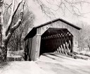
| Date: | 1957 |
|---|---|
| Description: | Covered bridge over Cedar Creek in Ozaukee County on highway, about one mile north of Cedarburg. The last remaining covered bridge in Wisconsin. Snow is on... |
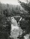
| Date: | 1900 |
|---|---|
| Description: | Big Falls, looking down the Flambeau River. There are large boulders in the foreground and patches of ice in the river. Caption at bottom reads: "Big Falls... |
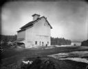
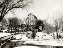
| Date: | 1900 |
|---|---|
| Description: | View across road towards two men standing facing each other just outside the front entrance to Glen and Star's Mill, near a brewery. There is snow on the g... |
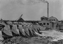
| Date: | 1913 |
|---|---|
| Description: | Dam and hydroelectric power house, with a billowing smokestack and a crane in the background. |
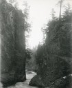
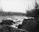
| Date: | 1929 |
|---|---|
| Description: | The gorge of the Bad River below Brownstone Falls. |
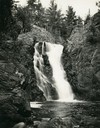
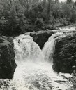
| Date: | 1935 |
|---|---|
| Description: | View from rocky shoreline towards the Brownstone Falls in Copper Falls State Park. |
| Date: | 1935 |
|---|---|
| Description: | Elevated view of the Brownstone Falls on the Bad River. |
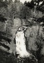
| Date: | 1937 |
|---|---|
| Description: | Elevated view of the waterfall where the Bad River tumbles over the Keweenawan Trap Ledge. |
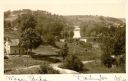
| Date: | 1900 |
|---|---|
| Description: | Elevated view of wagon bridge in Darlington, with a river on the right, a cow in a field, and a building on the left. |
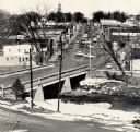
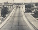
| Date: | 1959 |
|---|---|
| Description: | Elevated view of street with bridge in Darlington. Cars are parked in the center of the street at an angle. |

| Date: | 1910 |
|---|---|
| Description: | Elevated view of the Pecatonica River, which is curving from left to right, making two hairpin turns among fields and trees. Hills are in the distance. |
| Date: | 1909 |
|---|---|
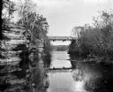
| Description: | View from river of Dell Creek bridge with bluff and birch trees on the left. |
| Date: | 1932 |
|---|---|
| Description: | Elevated view of the bridge over a river. The Nicolet Paper Company is at the end of the bridge on the far shoreline. |
| Date: | 1935 |
|---|---|
| Description: | View towards bridge. The Nicolet Paper Company is on the left. |

| Date: | 1930 |
|---|---|
| Description: | Elevated view of the bridge over the Fox river, and the Nicolet Paper Company on the far shoreline. |
| Date: | 1932 |
|---|---|
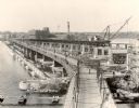
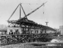
| Description: | View of the bridge under construction, with a crane atop the structure. Eight men are standing on scaffolding below the bridge. The Nicolet Paper Company ... |
| Date: | 1935 |
|---|---|
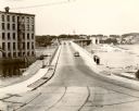
| Description: | Elevated view of the bridge, with several cars driving on it. On the left and right are streets below the bridge. In the distance are smokestacks and water... |

| Date: | 1900 |
|---|---|
| Description: | Elevated view down hill of the Fox River and the Little Rapids dam. |
If you didn't find the material you searched for, our Library Reference Staff can help.
Call our reference desk at 608-264-6535 or email us at: