Filter: Categories of Wisconsin Historical Images
Filter: Subject of Rivers
Filter: Year of 1900-1999
Filter: Type of Photograph
Filter: Categories of Wisconsin Historical Images
Filter: Subject of Rivers
Filter: Year of 1900-1999
Filter: Type of Photograph
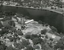
| Date: | 1948 |
|---|---|
| Description: | St. Norbert College campus on the Fox River. |
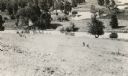
| Date: | 1900 |
|---|---|
| Description: | A woman stands in a marsh near the site of Eleazer William's first house. |

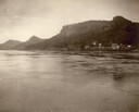
| Date: | 1902 |
|---|---|
| Description: | River with distant hills behind a town. An island is in the foreground. |
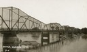
| Date: | 1911 |
|---|---|
| Description: | View towards the bridge along the left. Trees are along the opposite shoreline. Caption reads: "Bridge, Durand Wis." |

| Date: | 1930 |
|---|---|
| Description: | Aerial view of Carson Park, Half Moon Lake and part of the West Side in the foreground. The municipal bath house is on the lake shore in the foreground. A ... |

| Date: | 1930 |
|---|---|
| Description: | Aerial view of city, with Eau Claire River is in the foreground with Milwaukee railroad bridge at left. Gillette Rubber Co. plant is in center with Omaha r... |

| Date: | 1931 |
|---|---|
| Description: | Aerial view looking north, with a small portion of the West Side (left), nearly all of the North Side and part of the business district of the East Side. A... |
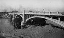
| Date: | 1930 |
|---|---|
| Description: | Madison Street Bridge, built in about 1925. View from shoreline across river with the bridge on the right. |
| Date: | 1900 |
|---|---|
| Description: | View up the Eau Claire River from the Dewey Street Bridge. The view shows the dam and linen mill and the site of the lower sawmill (called the "steam mill"... |

| Date: | 1906 |
|---|---|
| Description: | Elevated view of downtown Eau Claire. |
| Date: | 1930 |
|---|---|
| Description: | Carson Park on the Chippewa River, with the entrance to a tunnel which was used to transport logs from the river into Half Moon Lake. |

| Date: | 1900 |
|---|---|
| Description: | Elevated view of the Chippewa River and downtown Eau Claire. |

| Date: | 1920 |
|---|---|
| Description: | Site where the first French trading post in Wisconsin was built at the fork of the Fond du Lac River in 1787. The site is located near the city's gas plant... |

| Date: | 1956 |
|---|---|
| Description: | Aerial view looking northeast from a point over the east end of Middleton, showing the west end of Lake Mendota (right mid-ground). Fox Bluff juts into the... |
| Date: | 1915 |
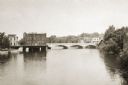
|---|---|
| Description: | View across water towards the Main Street Bridge over the Rock River. |
| Date: | 1900 |
|---|---|
| Description: | View of river and the building's exterior. This building is where Consolidated Water Power and Paper company operates its business. The building's facad... |
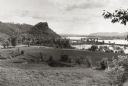
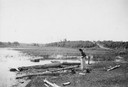
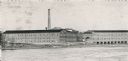
| Date: | 1953 |
|---|---|
| Description: | View across fields towards the Genoa Dam on the Mississippi River. Tree-covered hills are on the left. |
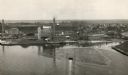
| Date: | 1920 |
|---|---|
| Description: | Aerial view of the conluence of the Fox River and the East River. The Northern Paper Mills are in the foreground and the city is seen to the right. |
If you didn't find the material you searched for, our Library Reference Staff can help.
Call our reference desk at 608-264-6535 or email us at: