Filter: Categories of Wisconsin Historical Images
Filter: Subject of Rivers
Filter: Year of 1900-1999
Filter: Creator Name of Unknown
Filter: County of Columbia
Filter: Categories of Wisconsin Historical Images
Filter: Subject of Rivers
Filter: Year of 1900-1999
Filter: Creator Name of Unknown
Filter: County of Columbia

| Date: | 1910 |
|---|---|
| Description: | View down the canal, with buildings along the shoreline, and a boat coming down the canal. |
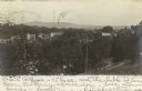
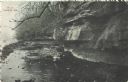
| Date: | 1900 |
|---|---|
| Description: | Elevated view from hill looking over a river towards Lodi, Wisconsin. Hills are in the distance. |
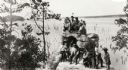
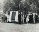
| Date: | 1920 |
|---|---|
| Description: | A group of Indians, probably Ho-Chunk, in traditional costume, posing on and around Demon's Anvil. |

| Date: | 1925 |
|---|---|
| Description: | The Pierre Pauquette monument located at the easterm terminus of the Wauona Trail. Erected by the Wau-bun Chapter of the Daughters of the American Revoluti... |
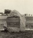
| Date: | 1925 |
|---|---|
| Description: | A view of the Pierre Pauquette monument located at the eastern terminus of the Wauona Trail. Erected by the Wau-bun Chapter of the Daughters of the America... |
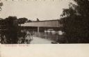
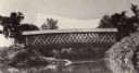
| Date: | 1900 |
|---|---|
| Description: | Covered bridge over river. Caption reads: "The Old Bridge, Portage, Wis." |

| Date: | 1915 |
|---|---|
| Description: | The Portage canal looking east from the Canal Bridge. Boats are lines up along the shoreline on the left near a long building. |
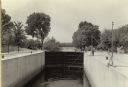
| Date: | 1935 |
|---|---|
| Description: | A view of the Portage Canal. In the immediate foreground is the Fox River, then the lower locks and the canal itself. The Indian Agency House may be seen t... |

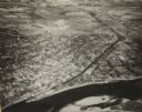
| Date: | 1945 |
|---|---|
| Description: | An aerial view of the Portage Canal, Fox and Wisconsin Rivers. |
| Date: | 1935 |
|---|---|
| Description: | A view of the canal locks of the Portage Canal. Men are standing at the edge of the locks on the right. |
| Date: | 1945 |
|---|---|
| Description: | An elevated view of Portage and it's vicinity. |
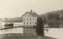
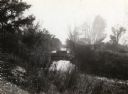
| Date: | 10 13 1911 |
|---|---|
| Description: | Elevated view of a mill during a flood, with a man standing on the left between a bridge and the mill. A house is on the side of a tree-covered hill on the... |

| Date: | 03 16 1965 |
|---|---|
| Description: | Anthony Wise in a necktie and hat standing next to a Native American wearing a feather headress, on a boat adjacent to a dock. |
| Date: | 05 03 1909 |
|---|---|
| Description: | Colorized postcard of the Dells near Cambria. Text in upper left corner reads "'Dells,' Cambria, Wis." |

| Date: | 1910 |
|---|---|
| Description: | Photographic postcard of an elevated view looking across the downtown area. The Crawfish River is on the left. Caption reads: "Bird's-Eye View, Columbus, W... |

| Date: | 1914 |
|---|---|
| Description: | This photostat map shows Fort Winnebago around 1931, land to be reserved for military purposes, roads to Fort Howard and Fort Crawford, "private property" ... |

| Date: | 1900 |
|---|---|
| Description: | This manuscript map shows outline of Fort Winnebago reserve land, Fort Winnebago, claim of A. Grignon, and Indian boundaries. The Fox River and Swan Lake a... |
| Date: | 06 30 1957 |
|---|---|
| Description: | View across lawn towards a crowd, with costumed participants dressed as Native Americans, fur traders, and Jacques Marquette, at the dedication of the Marq... |

| Date: | 1958 |
|---|---|
| Description: | Wisconsin Dells commercial photographer, John Trumble, with his Hasselblad. He is standing in front of Hurlbut Creek, probably in spring. Jack Grey, head o... |
If you didn't find the material you searched for, our Library Reference Staff can help.
Call our reference desk at 608-264-6535 or email us at: