 Filter: Categories of Wisconsin Historical Images
Filter: Subject of Rivers
Filter: Year of 1900-1999
Filter: Community of Appleton
Filter: Categories of Wisconsin Historical Images
Filter: Subject of Rivers
Filter: Year of 1900-1999
Filter: Community of Appleton
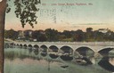
| Date: | 1911 |
|---|---|
| Description: | View from shoreline toward the bridge. Caption reads: "John Street Bridge, Appleton, Wis." |
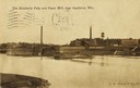
| Date: | 1912 |
|---|---|
| Description: | View from shoreline toward the mill on the opposite shoreline. Caption reads: "Kimberly Pulp and Paper Mill, near Appleton, Wis." |
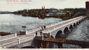
| Date: | 1906 |
|---|---|
| Description: | Elevated view of the bridge, which is intersected by a railroad bridge. Caption reads: "John St. Bridge, Appleton, Wis. Largest stone arch bridge in Wiscon... |
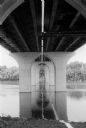
| Date: | 06 30 1992 |
|---|---|
| Description: | View from below of the Fox River Bridge. Gordon Neitzke who photographed the Fox River Bridge for the Wisconsin Department of Highways, found an almost cat... |
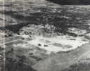
| Date: | 1955 |
|---|---|
| Description: | Aerial view of Valley Fair Mall, with a residential area beyond it on both sides of a river, all surrounded by trees and farmland. |

| Date: | 08 05 1962 |
|---|---|
| Description: | Mr. Ortel, a United States Government lock-keeper at Appleton lock number one on the Fox River canal. Mr. Ortel is opening the sluice gates to allow water ... |
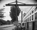
| Date: | 08 05 1962 |
|---|---|
| Description: | Exterior view of Riverside Paper Corporation mill. On the left is a road along a river, and on the right are railroad tracks along the mill. A sign in the ... |
| Date: | 06 12 1908 |
|---|---|
| Description: | Colorized postcard looking down hill of the Fox River through the trees. A bridge is spanning the river, and piles of lumber are on the shoreline. Caption ... |
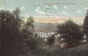
| Date: | 12 23 1905 |
|---|---|
| Description: | Elevated view of Lake Street bridge and nearby locks along the Fox River. Caption reads: "Lake Street Bridge, Appleton, Wis." |

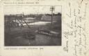
| Date: | 10 11 1909 |
|---|---|
| Description: | View of Potato Point. Trees line the shoreline of the Fox River. Boaters and fishermen are in the background. Caption reads: "Potato Point, Appleton, Wis." |
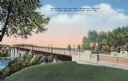
| Date: | 06 26 1939 |
|---|---|
| Description: | Colorized postcard view from hill toward the bridge along the right crossing the river. The bridge was completed in 1924. Caption reads: "Soldiers' and Sai... |

| Date: | 08 03 1905 |
|---|---|
| Description: | Photographic postcard of a scene of the Fox River near Lawrence University. The Main Building at Lawrence University can be seen in the background on the r... |

| Date: | 1952 |
|---|---|
| Description: | Map shows roads, highways, railroads, parks, city buildings, schools, cemeteries, city limits, and the Fox River. The map is indexed by street name, street... |

| Date: | 1916 |
|---|---|
| Description: | Map shows roads, railroads, the Fox River, parks, and cemeteries. Wards are numbered and the edges of the map feature coordinates. The top left of the map ... |

| Date: | 1921 |
|---|---|
| Description: | Map reads: "1918. Revised 1921." Key to the map in upper right hand corner reads: "Residential Districts," "Local Businesses," "Commercial and Light Manufa... |

| Date: | 1931 |
|---|---|
| Description: | Map shows street map with wards numbered, the Fox River, railroads, playgrounds, cemeteries, and schools. The map also includes a manuscript annotation ind... |

| Date: | 01 1940 |
|---|---|
| Description: | Map shows roads, railroads, the Fox River, parks, schools, and cemeteries and is indexed by street name in the margins. The bottom of the map show the Winn... |

| Date: | 04 1956 |
|---|---|
| Description: | Map includes an index for building locations on the Lawrence University campus in the upper right hand corner. Map shows roads, rivers, campus buildings by... |

| Date: | 1957 |
|---|---|
| Description: | Map is indexed by street name in the margins. The map shows roads, highways, railroads, parks, city buildings, schools, cemeteries, city limits, and the Fo... |

| Date: | 1968 |
|---|---|
| Description: | This map shows local streets, wards, buildings, parks, and part of the Fox River. The map is also indexed by street name. Ward borders and numbering and th... |
If you didn't find the material you searched for, our Library Reference Staff can help.
Call our reference desk at 608-264-6535 or email us at: