 Filter: Categories of Wisconsin Historical Images
Filter: Subject of Rivers
Filter: Year of 1900-1999
Filter: Community of Beloit
Filter: Categories of Wisconsin Historical Images
Filter: Subject of Rivers
Filter: Year of 1900-1999
Filter: Community of Beloit
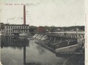
| Date: | 1905 |
|---|---|
| Description: | View of the dam and power plant over the river, with smokestacks in the background. Caption reads: "The Dam, Beloit, Wis." |
| Date: | 1905 |
|---|---|
| Description: | Elevated view of the river, with railroad tracks on the left shoreline, and a railroad bridge crossing the river. Caption reads: "View of River from Grand ... |

| Date: | 1905 |
|---|---|
| Description: | View of the Rock River with the Northwestern Railroad Bridge in the foreground and Beloit in the background. Caption reads: "Bird's-Eye View of River, Belo... |
| Date: | 1905 |
|---|---|
| Description: | Elevated view of the Rock River. Caption reads: "Rock River, N.W. Ry. Bridge, and glimpse of Beloit, Wis." |
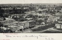
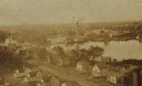
| Date: | 1900 |
|---|---|
| Description: | Elevated view of downtown. Caption reads: "Bird's-eye view of Beloit." |
| Date: | 1900 |
|---|---|
| Description: | Elevated view over houses towards the industrial area along the Rock River. |
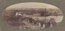
| Date: | 1900 |
|---|---|
| Description: | Oval-framed view of the industrial area along the Rock River. |

| Date: | 1905 |
|---|---|
| Description: | View towards river. Caption reads: "Bird's Eye View, Beloit, Wis." |
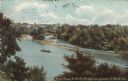
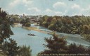
| Date: | 1909 |
|---|---|
| Description: | Colorized postcard of an elevated view through trees of the Rock River, with a railroad bridge and a glimpse of Beloit. There are boaters near sandbars in ... |

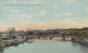
| Date: | 1910 |
|---|---|
| Description: | Colorized postcard view from riverbank of the Upper Bridge crossing the Rock River into Beloit. A man is in a rowboat in the foreground. In the background ... |

| Date: | 1911 |
|---|---|
| Description: | Colorized postcard of an elevated view across a dam towards a factory on the Rock River. Dwellings are on the far bank on the right. Caption reads: "The Da... |

| Date: | 1973 |
|---|---|
| Description: | This map is a photocopy of the original plat of Beloit from 1838. The map shows labeled roads, lots, and rivers. |
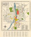
| Date: | 1952 |
|---|---|
| Description: | This colorful map of Beloit shows roads, railroads, rivers, creeks, business districts, industrial areas, and parks and recreation areas. The map includes ... |
If you didn't find the material you searched for, our Library Reference Staff can help.
Call our reference desk at 608-264-6535 or email us at: