 Filter: Categories of Wisconsin Historical Images
Filter: Subject of Rivers
Filter: Year of 1900-1999
Filter: Community of Green Bay
Filter: Year of 1900-1909
Filter: Categories of Wisconsin Historical Images
Filter: Subject of Rivers
Filter: Year of 1900-1999
Filter: Community of Green Bay
Filter: Year of 1900-1909
| Date: | 1909 |
|---|---|
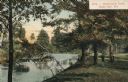
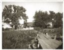
| Description: | View people standing on the shoreline of Dutchman's Creek. Caption reads: "Dutchman's Creek, Green Bay, Wis." |
| Date: | 1909 |
|---|---|
| Description: | Elevated view of the Fox River near the site of Fort Howard. Caption reads: "Old Fort Howard at Cross Fox River, Green Bay, Wis." |
| Date: | 1900 |
|---|---|
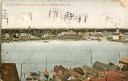
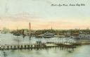
| Description: | Looking North. Harbor with boats, bridge, and buildings. |
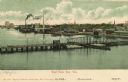
| Date: | 1900 |
|---|---|
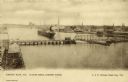
| Description: | Elevated view of east Green Bay harbor with cargo ships, W.W. Cagill Co., and other various industries. |
| Date: | 1905 |
|---|---|
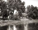
| Description: | View of the Tank cottage before restoration on its original site. |
| Date: | 1908 |
|---|---|
| Description: | View of the Tank cottage on its original site on the west side of the Fox River. The cottage was built in 1776 by Joseph Roi, a fur trader, who lived in it... |
| Date: | 1905 |
|---|---|
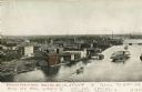
| Description: | Elevated view of bridges and the Fox River. Caption reads: "Bird's Eye View, Green Bay, Wis." |
| Date: | 1906 |
|---|---|
| Description: | Elevated view of Fox River in the river district. Caption reads: "Bird's-eye View of River, Green Bay, Wis." |
| Date: | 1906 |
|---|---|
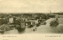
| Description: | Elevated view of East Green Bay, Fox River, and various buildings belonging to the manufacturing industry. Caption reads: "East Green Bay, Wis." |

| Date: | 1906 |
|---|---|
| Description: | View from Fox River of chimneys, buildings, and boat. Caption reads: "River Front, Green Bay, Wis." |

| Date: | 1900 |
|---|---|
| Description: | This map of Green Bay shows plat of the town, lots by number, local streets, the military Fort Howard, part of Fox River and part of Navarino. The map feat... |

| Date: | 1906 |
|---|---|
| Description: | This map shows streets, railroads, land use, public buildings, commercial businesses, and the Menominee River. Depths are shown by gradient tints and sound... |

| Date: | 1907 |
|---|---|
| Description: | Sanborn map of Green Bay including St. George and Main Streets. |

| Date: | 1907 |
|---|---|
| Description: | Sanborn map of Green Bay featuring Elm, Cedar and Main Streets. |

| Date: | 1900 |
|---|---|
| Description: | This photostat map was probably originally created in 1835 and shows in addition to private claims, mills, roads, and trails. Green Bay and the Fox River a... |

| Date: | 1900 |
|---|---|
| Description: | This photocopied map shows private claim owners, buildings, and land use in 1818. Insets show Fort Howard and the caption reads: "A view of the Fox River ... |

| Date: | 1900 |
|---|---|
| Description: | This set of maps contains four sheets: "Landownership in the Vicinity of Military Reserve and Fort Howard," "Houses Along the River Road to Green Bay," "Ow... |
If you didn't find the material you searched for, our Library Reference Staff can help.
Call our reference desk at 608-264-6535 or email us at: