 Filter: Categories of Wisconsin Historical Images
Filter: Subject of Rivers
Filter: Year of 1900-1999
Filter: Community of Milwaukee
Filter: Categories of Wisconsin Historical Images
Filter: Subject of Rivers
Filter: Year of 1900-1999
Filter: Community of Milwaukee

| Date: | 1942 |
|---|---|
| Description: | This map shows the route of the Milwaukee Road, roads, foot trails, resorts, and ranger stations. The map includes text, illustrations, a railroad fare tab... |
| Date: | 1925 |
|---|---|
| Description: | This map shows the routes of half-day and all-day trips from the Milwaukee area. The map highlights roads, land parcels, routes and destinations. Lake Mic... |

| Date: | 04 1926 |
|---|---|
| Description: | This blueprint map shows plats and includes water surface diagram and "history of the harbor." The Kinnickinnic River and the Milwaukee River are labelled.... |

| Date: | 1956 |
|---|---|
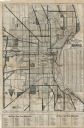
| Description: | This map shows city, suburban, parochial and other types schools, with an explanation of symbols in the right margin. The original caption for the map read... |

| Date: | 1966 |
|---|---|
| Description: | This map shows city, suburban, parochial and other types schools, with an explanation of symbols in the right margin. The original caption for the map read... |
| Date: | 1967 |
|---|---|
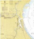
| Description: | This map shows the harbor, streets, and some buildings. Also includes the Menomonee River, the Kinnickinnic River, the Municipal mooring Basin, and Lake Mi... |
| Date: | 1940 |
|---|---|
| Description: | This map is pen and ink on paper and is map 2 in a series of 12. The map shows streets, the Milwaukee River, and railroad tracks. |
| Date: | 1940 |
|---|---|
| Description: | This map is pen and ink on paper and is map 3 in a series of 12. The map shows streets, the Milwaukee River, and railroad tracks. |
| Date: | 1940 |
|---|---|
| Description: | This map is pen and ink on paper and is map 3 in a series of 12. The map shows streets, and the Milwaukee River. |
| Date: | 1940 |
|---|---|
| Description: | This map is pen and ink on paper and is map 5 in a series of 12. The map shows streets, the Milwaukee River, Lake Michigan, and railroad tracks. |
| Date: | 1940 |
|---|---|
| Description: | This map is pen and ink on paper and is map 6 in a series of 12. The map shows streets, and the Milwaukee River. |
| Date: | 1940 |
|---|---|
| Description: | This map is pen and ink on paper and is map 7 in a series of 12. The map shows streets and a railroad line. |
| Date: | 1940 |
|---|---|
| Description: | This map is pen and ink on paper and is map 12 in a series of 12. The map shows streets, railroad lines, the Kinnickinnic River, and Lake Michigan. |

| Date: | 1942 |
|---|---|
| Description: | This photostat map shows roads, ferry, impassible marsh land, the Menominee River, the Milwaukee River, and Lake Michigan. |

| Date: | 1965 |
|---|---|
| Description: | This series of 17 maps show boundaries and changes in city limits from 1846 to 1965. The base of all of the maps are the same, Milwaukee and suburbs. All m... |
| Date: | 1925 |
|---|---|
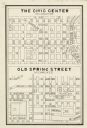
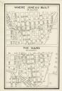
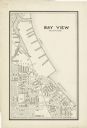
| Description: | This series of 11 maps plus an index show the rivers as well as riverside buildings, landownership, and streets. |

| Date: | 07 1936 |
|---|---|
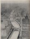
| Description: | Elevated view of vast piles of coal dominate this scene of the Milwaukee Harbor. A bridge crane is in the center, with two other cranes at the far left. Th... |
| Date: | 1904 |
|---|---|
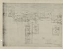
| Description: | Alfred Clas design drawing of a scheme for the improvement of the Milwaukee River, with possibilities of narrowing the river and paralleling the banks with... |

| Date: | 1910 |
|---|---|
| Description: | Sanborn insurance map of Milwaukee showing a portion of Jones Island with Lake Michigan at the top and the Milwaukee River at the bottom. |

| Date: | 1955 |
|---|---|
| Description: | Industries along the Milwaukee River, one of which is the Schlitz Brewery. |
If you didn't find the material you searched for, our Library Reference Staff can help.
Call our reference desk at 608-264-6535 or email us at: