 Filter: Categories of Wisconsin Historical Images
Filter: Subject of Rivers
Filter: Year of 1900-1999
Filter: Community of Prairie du Chien
Filter: Categories of Wisconsin Historical Images
Filter: Subject of Rivers
Filter: Year of 1900-1999
Filter: Community of Prairie du Chien
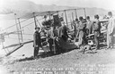
| Date: | 10 19 1911 |
|---|---|
| Description: | Pilot Hugh Robinson and his Curtiss hydroplane at Prairie du Chien during a flight that was intended to be the first all the way down the Mississippi River... |

| Date: | 1900 |
|---|---|
| Description: | This map shows a line, marked with latitude and longitude coordinates that runs through Prairie du Chien. Only a few features beyond this line are displaye... |

| Date: | 1900 |
|---|---|
| Description: | This photocopy map shows marshes, woods, buildings, and selected features including islands, mounds, old Fort Crawford, and "new site for a fort in questio... |
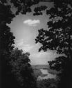
| Date: | 1950 |
|---|---|
| Description: | Elevated view of the Wisconsin River from Wyalusing State Park, framed by trees. There is a bridge over the river in the distance. |
If you didn't find the material you searched for, our Library Reference Staff can help.
Call our reference desk at 608-264-6535 or email us at: