Filter: Categories of Wisconsin Historical Images
Filter: Subject of Rivers
Filter: Year of 1900-1999
Filter: County of Crawford
Filter: Categories of Wisconsin Historical Images
Filter: Subject of Rivers
Filter: Year of 1900-1999
Filter: County of Crawford

| Date: | 1905 |
|---|---|
| Description: | Elevated view of Soldiers' Grove with a bridge in the foreground. |
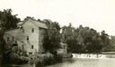
| Date: | 1920 |
|---|---|
| Description: | A large building, possibly a mill, next to a river. |
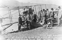
| Date: | 10 19 1911 |
|---|---|
| Description: | Pilot Hugh Robinson and his Curtiss hydroplane at Prairie du Chien during a flight that was intended to be the first all the way down the Mississippi River... |
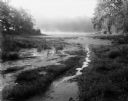
| Date: | 08 13 1961 |
|---|---|
| Description: | A Wisconsin River swamp. The swampy area is framed by trees with more trees in the background hidden by fog. |

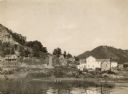
| Date: | 1902 |
|---|---|
| Description: | River with distant hills behind a town. An island is in the foreground. |

| Date: | 1908 |
|---|---|
| Description: | Elevated view of Wauzeka. A bridge over a river is in the background. |
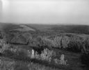
| Date: | 09 10 1961 |
|---|---|
| Description: | An elevated view, looking westward, of the Kickapoo River Valley. |

| Date: | 08 20 1961 |
|---|---|
| Description: | A tree-lined view of the Wisconsin River. The photograph was taken from an elevated area near a highway. |

| Date: | 1911 |
|---|---|
| Description: | Blue line print. Shows post offices, houses, schools, churches, roads, routes, rivers, and railroads. Includes explanation of symbols. "H.G.M. October 12,... |

| Date: | 1926 |
|---|---|
| Description: | View from hill looking down at homes and businesses in town. A bridge goes over the Kickapoo River. The depot and railroad tracks and Main Street are behin... |

| Date: | 1900 |
|---|---|
| Description: | This map shows a line, marked with latitude and longitude coordinates that runs through Prairie du Chien. Only a few features beyond this line are displaye... |

| Date: | 1900 |
|---|---|
| Description: | This photocopy map shows marshes, woods, buildings, and selected features including islands, mounds, old Fort Crawford, and "new site for a fort in questio... |
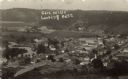
| Date: | 1918 |
|---|---|
| Description: | Elevated view of central Gays Mills. The school is in the lower left. A church is on the right. Caption reads: "Gays Mills, Looking East.: |
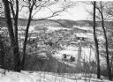
| Date: | 1982 |
|---|---|
| Description: | Bare trees frame an elevated view of Gays Mills taken from a snowy hilltop, showing Highway 131, lower right, as it curves into Main Street. Highway 171 en... |
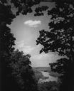
| Date: | 1950 |
|---|---|
| Description: | Elevated view of the Wisconsin River from Wyalusing State Park, framed by trees. There is a bridge over the river in the distance. |

| Date: | 1910 |
|---|---|
| Description: | Text on front reads: "Kickapoo River Scene, Wauzeka, Wis." Elevated view of the shore of the Kickapoo River, with boats, piers and boathouses. A man in a r... |
If you didn't find the material you searched for, our Library Reference Staff can help.
Call our reference desk at 608-264-6535 or email us at: