Filter: Categories of Wisconsin Historical Images
Filter: Subject of Rivers
Filter: Year of 1900-1999
Filter: County of Dane
Filter: Year of 1910-1919
Filter: Categories of Wisconsin Historical Images
Filter: Subject of Rivers
Filter: Year of 1900-1999
Filter: County of Dane
Filter: Year of 1910-1919

| Date: | 1910 |
|---|---|
| Description: | Map of Dane County rural delivery in Madison and the town of Westport. |

| Date: | 1910 |
|---|---|
| Description: | Map of the general plan of the district of the Four Lakes. |

| Date: | 1911 |
|---|---|
| Description: | Plat Map of Blooming Grove in "Atlas of Dane County, Wisconsin." |
| Date: | 1910 |
|---|---|
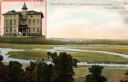
| Description: | View of the outdoor landscape as seen from a window in the Stoughton Hospital, along with an inset of the building in the upper left corner. Caption reads:... |

| Date: | 1910 |
|---|---|
| Description: | Scale: 1:62500. Topography by Robert Muldrow. Surveyed in 1904. Edition of Aug. 1906, reprinted in 1910. |
| Date: | 1910 |
|---|---|
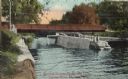
| Description: | View of the Sherman Bridge and Lock and surrounding area on the Yahara River. Caption reads: "Sherman Avenue Bridge and Locks, Yahara River, Madison, Wis." |
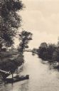
| Date: | 1910 |
|---|---|
| Description: | Elevated view looking down the Yahara River. In the foreground a canoe is tied to a small dock, and in the background is a bridge. |
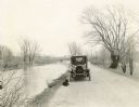
| Date: | 1918 |
|---|---|
| Description: | The Richard Lloyd Jones family dog lies in front of the car parked along the Yahara River Parkway in Tenney Park. Four family members sit in the car. Ther... |
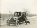
| Date: | 1918 |
|---|---|
| Description: | Dick Lloyd Jones stands on the running board of the family car parked along the Yahara River Parkway in Tenney Park. Blig, the family's Belgian Shepherd d... |

| Date: | 1918 |
|---|---|
| Description: | View from shoreline of people rowing on the Yahara River on Madison's East Side. The Malt House, 1603 Sherman Avenue, is in the background. |

| Date: | 1918 |
|---|---|
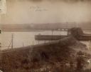
| Description: | Looking along the newly dredged Yahara River between Lakes Monona and Waubesa. |
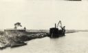
| Date: | 1918 |
|---|---|
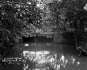
| Description: | The dredge used for clearing the channel of the Yahara River between Lakes Monona and Waubesa. Two cottages are on the shore and a rowboat is tied along t... |

| Date: | 1918 |
|---|---|
| Description: | Elevated view from hill of Yahara River flowing into Lake Kegonsa. |

| Date: | 1918 |
|---|---|
| Description: | Yahara River flowing out of Lake Kegonsa. There appears to be a boat house on the shoreline in the background. |

| Date: | 1918 |
|---|---|
| Description: | Elevated view from hill of the Yahara River flowing south after leaving Lake Kegonsa. Last photo in the album, with the following statement "The little Ya... |

| Date: | 1911 |
|---|---|
| Description: | A map of the village of Black Earth and Verona. |
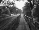
| Date: | 1912 |
|---|---|
| Description: | A bridge with both a wooden walkway for pedestrians and a dirt road for automobiles. Two men and a horse are standing on the other side of the bridge. |
If you didn't find the material you searched for, our Library Reference Staff can help.
Call our reference desk at 608-264-6535 or email us at: