Filter: Categories of Wisconsin Historical Images
Filter: Subject of Rivers
Filter: Year of 1900-1999
Filter: County of Iron
Filter: Categories of Wisconsin Historical Images
Filter: Subject of Rivers
Filter: Year of 1900-1999
Filter: County of Iron

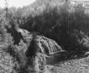
| Date: | 1935 |
|---|---|
| Description: | Men fishing out of wooden rowboats on the Turtle flowage near the Turtle Dam on the Flambeau River. |

| Date: | 1935 |
|---|---|
| Description: | Group of people gathered on and near the Turtle Dam of the Flambeau River. View from the Turtle Flowage side of the dam. |
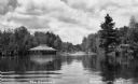
| Date: | 1934 |
|---|---|
| Description: | View of the cabins or bunkhouses of Camp Mercer across the Manitowish River. |
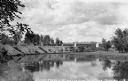
| Date: | 1932 |
|---|---|
| Description: | View across water of The Flowage showing the Mercer Fish Hatchery building on the left. Two people are in a boat on the far left, a bridge is in the center... |

| Date: | 1905 |
|---|---|
| Description: | This early 20th century map identifies the locations of the Divide Resort and Spider Lake Resort in Vilas County, Wisconsin. Also shown are trails, stage l... |

| Date: | 1937 |
|---|---|
| Description: | "Prepared ... March 1937." Includes location map. "State of Wisconsin, Conservation Department, Map Division"--upper left. From the E.P. Sherry papers rela... |

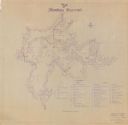
| Date: | 1941 |
|---|---|
| Description: | This is map one of three maps that show trails, roads and fire lanes, utilities, resorts, submerged lakes, vegetation, flowage right lands, and timber righ... |

| Date: | 1909 |
|---|---|
| Description: | This map covers Iron and Price Counties and portions of Sawyer and Oneida Counties. The map shows vacant and sold Wis. Central Ry. land, settlers houses, s... |
| Date: | 1941 |
|---|---|
| Description: | This is map two of a set of three and shows boundaries and flowage right lands in red ink. A legend in the lower right corner includes a legend of symbols ... |

| Date: | 1941 |
|---|---|
| Description: | This is map three of a set of three, and shows trails, roads and fire lanes, utilities, resorts, submerged lakes, vegetation, flowage right lands, and timb... |

| Date: | 1930 |
|---|---|
| Description: | This map shows schools, school districts, town sections, highways, railroads, and hydrography of the area around Hurley. The right margin includes and expl... |

| Date: | 1905 |
|---|---|
| Description: | Slightly elevated view of the border between Hurley, WI and Ironwood, MI. Caption reads: "Looking east from Hurley side of Montreal River near Silver Stree... |
If you didn't find the material you searched for, our Library Reference Staff can help.
Call our reference desk at 608-264-6535 or email us at: