 Filter: Categories of Wisconsin Historical Images
Filter: Subject of Rivers
Filter: Year of 1900-1999
Filter: County of Marinette
Filter: Categories of Wisconsin Historical Images
Filter: Subject of Rivers
Filter: Year of 1900-1999
Filter: County of Marinette
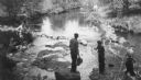
| Date: | 1945 |
|---|---|
| Description: | Two fishermen on rocks alongside the Pike River. |
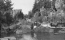
| Date: | 1900 |
|---|---|
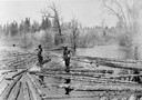
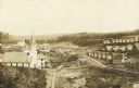
| Description: | Log pond with two lumberjacks walking on the floating logs and sorting them in the Peshtigo River area. |
| Date: | 1945 |
|---|---|
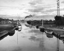
| Description: | Harbor in Marinette at sunset. Boats are docked at the sides of a canal. Smoke pours from smokestacks of a facility in the distance. |
| Date: | 1963 |
|---|---|
| Description: | H.P. Christ Feed Mill. The first building across the street is the Atlas Hotel which was located at the site of the present Milo Howarth senior home. Other... |

| Date: | 1905 |
|---|---|
| Description: | View from shoreline toward the new Hattie Street Bridge. Factory buildings are on the shoreline behind. Caption reads: "New Hattie Street Bridge, Marinette... |
| Date: | 1908 |
|---|---|
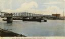
| Description: | View from dock toward the drawbridge. Caption reads: "Drawbridge from Menekaunee Dock, Marinette, Wis." |
| Date: | 1910 |
|---|---|
| Description: | An elevated view of town. A church is on the left, houses are in rows on the right. Caption reads: "Made-For-Club-House — Niagara-Wis.—". |

| Date: | 1941 |
|---|---|
| Description: | A tourist map of Marinette County, Wisconsin that includes indexes of the lakes and rivers in the county which also identify the fish present, a list of ra... |

| Date: | 1912 |
|---|---|
| Description: | Shows wards, sections, plat additions, selected buildings, churches, schools, and manufacturing companies. "We have revised this map from H. McCallum’s 189... |

| Date: | 1951 |
|---|---|
| Description: | Water depths shown by bathymetric tints and soundings. Relief shown by contours. "Depths in feet." "Aids to navigation corrected to May 4, 1951." On verso:... |

| Date: | 1910 |
|---|---|
| Description: | Photographic postcard view of High Falls. Caption reads: "High Falls, Crivitz, Wis." |

| Date: | 1912 |
|---|---|
| Description: | This blueprint manuscript map shows selected buildings, roads, and the Peshtigo River. |

| Date: | 1920 |
|---|---|
| Description: | This map shows a small island in the Menominee River and includes a survey table and certification. |

| Date: | 1905 |
|---|---|
| Description: | This photocopied map shows landownership, roads, railroads, rural mail routes, churches, school houses, cemeteries, and townships. The map includes adverti... |

| Date: | 1912 |
|---|---|
| Description: | Marinette County, Township 37 N., Range 20 E. |

| Date: | 1912 |
|---|---|
| Description: | A portion of a plat map of Marinette County showing township 30 N., range 21 E., and part of township 29 N., range 21 E. |
| Date: | 1922 |
|---|---|
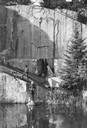
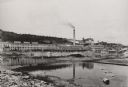
| Description: | View across water towards the Niagara Paper Mill. |
| Date: | 07 1936 |
|---|---|
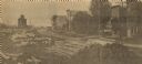
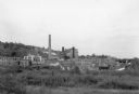
| Description: | View across field towards large smokestack towering above the complex of buildings at the Niagara paper mill. On the far right, water is flowing through th... |
| Date: | 06 1936 |
|---|---|
| Description: | Elevated view of a man, on the left, approaching three youths working on the Thunder River. One of the youths is holding a bucket while the others, standin... |
| Date: | 1937 |
|---|---|
| Description: | View across water towards an unidentified man and woman sitting on rocks at the edge of the Pike River, with Dave's Falls behind them. |
If you didn't find the material you searched for, our Library Reference Staff can help.
Call our reference desk at 608-264-6535 or email us at: