 Filter: Categories of Wisconsin Historical Images
Filter: Subject of Rivers
Filter: Year of 1900-1999
Filter: County of Milwaukee
Filter: Categories of Wisconsin Historical Images
Filter: Subject of Rivers
Filter: Year of 1900-1999
Filter: County of Milwaukee
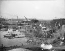
| Date: | 10 28 1938 |
|---|---|
| Description: | Elevated view of bay shoreline, with dwellings along the bank. A few boats are in the river. In the background is a factory with a smokestack and railroad ... |

| Date: | 1914 |
|---|---|
| Description: | View of downtown Milwaukee riverbank before the First National Bank was built in 1914. Advertising painted on the sides of buildings includes B. Mock & So... |
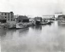
| Date: | 1938 |
|---|---|
| Description: | Elevated view of a boat owned by Julius Dettloff docked along the edge of a river. The boat was powered by an International PD-40 power unit; in the backgr... |

| Date: | 1900 |
|---|---|
| Description: | Aunt Helen and Syl standing on an overlook at River Park. Behind them is a bridge spanning a wide river. |

| Date: | 1901 |
|---|---|
| Description: | Syl and aunt Helen in a rowboat on the Milwaukee River at Gordon Park. In the background a large bridge crosses the river. On the right the banks of the ri... |
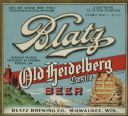
| Date: | 1933 |
|---|---|
| Description: | Label submitted to the state of Wisconsin for trademark registration. "Blatz, Old Heidelberg Castle, Beer, Blatz Brewing Co." Pictured on the label is a sc... |
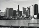
| Date: | 1938 |
|---|---|
| Description: | View across the Kinnickinnic River of the Pabst brewery grain elevator. A Schlitz building, possibly one of their grain elevators, stands behind the Pabst ... |

| Date: | 1976 |
|---|---|
| Description: | An 1876 reprinted map of the Township of Franklin, Milwaukee County, Wisconsin, that shows the land ownership and sectioning of the town, as well as the ro... |

| Date: | 1902 |
|---|---|
| Description: | A map of Milwaukee County, Wisconsin that shows the township and range system, sections, towns, roads, railroads and rail stations, cities and villages, po... |

| Date: | 1922 |
|---|---|
| Description: | A road map of Milwaukee County, Wisconsin that shows the township and range system, towns, communities, completed roads, a proposed system of roads, steam ... |

| Date: | 1940 |
|---|---|
| Description: | Map of Milwaukee County showing the metropolitan area, in yellow, and the proposed connecting of parkways and boulevards in green. The map also identifies ... |

| Date: | 1940 |
|---|---|
| Description: | A map of Milwaukee County, showing the route of the county tour of Milwaukee in the dark line, as well as identifying other roads, streets, and the Root, M... |

| Date: | 1976 |
|---|---|
| Description: | A street map of Milwaukee County, Wisconsin that identifies the location of schools, hospitals, parks, beaches, streets, freeways, both planned or under co... |

| Date: | 1965 |
|---|---|
| Description: | A map of Milwaukee County showing the county supervisor districts and the city wards. The map also includes the names of those on the on the board of elect... |

| Date: | 1902 |
|---|---|
| Description: | Map reads: "Milwaukee's Polish Population. Map showing in Red Color the Location and Density of Polish=Speaking Population of the City of Milwaukee, Wis." ... |

| Date: | 1911 |
|---|---|
| Description: | Map printed in the Milwaukee Herald, 16th of February, 1912. Includes list of Assembly, State Senate, and Congressional districts in bottom margin. Contain... |

| Date: | 1931 |
|---|---|
| Description: | This map is an advertisement for Milwaukee street cars and motor buses and reads: "Ride the street car or motor bus. Economical, safe, dependable." Include... |

| Date: | 1950 |
|---|---|
| Description: | This map is accompanied by booklet: "Know Milwaukee Map and Street Guide". The map is a detailed map of Milwaukee and the surrounding suburbs. Streets and ... |

| Date: | 1940 |
|---|---|
| Description: | This map is pen and ink on paper and is 1 map consisting of 12 sheets. This map includes a numbered key labeling each area, all of which are represented ... |

| Date: | 1940 |
|---|---|
| Description: | Shows Milwaukee and Waukesha counties, and parts of Dodge, Washington, Ozaukee, Jefferson, Walworth, and Racine counties. Includes indexes of "Cities, Town... |
If you didn't find the material you searched for, our Library Reference Staff can help.
Call our reference desk at 608-264-6535 or email us at: