 Filter: Categories of Wisconsin Historical Images
Filter: Subject of Rivers
Filter: Year of 1900-1999
Filter: County of Milwaukee
Filter: Year of 1950-1959
Filter: Categories of Wisconsin Historical Images
Filter: Subject of Rivers
Filter: Year of 1900-1999
Filter: County of Milwaukee
Filter: Year of 1950-1959

| Date: | 1950 |
|---|---|
| Description: | Looking south. Bridge in foreground is over Kinnickinnic River. Bridge over the road holds railroad tracks. In background are several houses and a build... |
| Date: | 1955 |
|---|---|
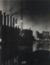
| Description: | Buildings and smokestacks along a riverfront. Sky darkened by the smoke. |

| Date: | 1950 |
|---|---|
| Description: | This map is accompanied by booklet: "Know Milwaukee Map and Street Guide". The map is a detailed map of Milwaukee and the surrounding suburbs. Streets and ... |

| Date: | 04 01 1958 |
|---|---|
| Description: | An antique 82-year-old horse-drawn hearse, pushed by pranksters into the Milwaukee River near the North Avenue bridge, being pulled out by a tow-truck, as ... |

| Date: | 1956 |
|---|---|
| Description: | This map shows city, suburban, parochial and other types schools, with an explanation of symbols in the right margin. The original caption for the map read... |
| Date: | 1955 |
|---|---|
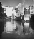
| Description: | Industries along the Milwaukee River, one of which is the Schlitz Brewery. |

| Date: | 1956 |
|---|---|
| Description: | Snow is mounded on top of pilings on the edge of the Milwaukee River. |
If you didn't find the material you searched for, our Library Reference Staff can help.
Call our reference desk at 608-264-6535 or email us at: