 Filter: Categories of Wisconsin Historical Images
Filter: Subject of Rivers
Filter: Year of 1900-1999
Filter: County of Outagamie
Filter: Year of 1950-1959
Filter: Categories of Wisconsin Historical Images
Filter: Subject of Rivers
Filter: Year of 1900-1999
Filter: County of Outagamie
Filter: Year of 1950-1959
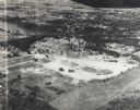
| Date: | 1955 |
|---|---|
| Description: | Aerial view of Valley Fair Mall, with a residential area beyond it on both sides of a river, all surrounded by trees and farmland. |

| Date: | 1952 |
|---|---|
| Description: | Map shows roads, highways, railroads, parks, city buildings, schools, cemeteries, city limits, and the Fox River. The map is indexed by street name, street... |

| Date: | 04 1956 |
|---|---|
| Description: | Map includes an index for building locations on the Lawrence University campus in the upper right hand corner. Map shows roads, rivers, campus buildings by... |

| Date: | 1957 |
|---|---|
| Description: | Map is indexed by street name in the margins. The map shows roads, highways, railroads, parks, city buildings, schools, cemeteries, city limits, and the Fo... |
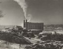
| Date: | 01 1950 |
|---|---|
| Description: | Winter image of the Interlake Pulp Mill in the Fox River Valley. The buildings are surrounded by large stacks of logs. The Fox River can be seen behind and... |
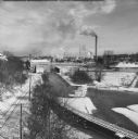
| Date: | 02 1951 |
|---|---|
| Description: | Elevated view of the Fox River Valley from Memorial Drive bridge, looking East. Snow is on the ground, ice is on the river and the smokestacks are billowin... |
If you didn't find the material you searched for, our Library Reference Staff can help.
Call our reference desk at 608-264-6535 or email us at: