 Filter: Categories of Wisconsin Historical Images
Filter: Subject of Rivers
Filter: Year of 1900-1999
Filter: County of Sauk
Filter: Categories of Wisconsin Historical Images
Filter: Subject of Rivers
Filter: Year of 1900-1999
Filter: County of Sauk
| Date: | 09 19 1961 |
|---|---|
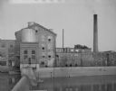
| Description: | View of a woolen mill, as seen from across a river and dam. |
| Date: | 1925 |
|---|---|
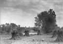
| Description: | Corn shocks stand in a field with several pumpkins on the ground. There is a stream or river along the field, and in the background is a bridge over a dam... |
| Date: | 1925 |
|---|---|
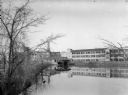
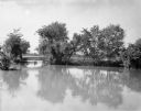
| Description: | View across river of a large mill or factory complex, possibly the Island Woolen Mill. In front of the mill is a roofed boathouse, with a canoe hanging fro... |
| Date: | 1930 |
|---|---|
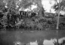
| Description: | View across river of a crowd gathered on a steep riverbank overlooking a submerged car. There is a large house at the top of the hill. |
| Date: | 1930 |
|---|---|
| Description: | A view of high water on a river, possibly the Baraboo River, in a rural setting. |
| Date: | 1920 |
|---|---|
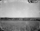
| Description: | A view of a rolling rural landscape, most likely in Sauk County. In the far distance are houses and farm buildings, a church and a larger building, center ... |
| Date: | 1925 |
|---|---|
| Description: | The Island Woolen Mill dam and bridge over the Baraboo River. In the foreground is a concrete "pergola" which shades a small bench. Molded into a concrete ... |

| Date: | 1925 |
|---|---|
| Description: | Two large clay block silos stand beside a river. There is a large building, possibly a mill, behind the silos, a barn to the right and a shed on the left. ... |
| Date: | 1936 |
|---|---|
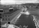
| Description: | Elevated view of the power dam on the Wisconsin River at Prairie du Sac. |
| Date: | 1924 |
|---|---|
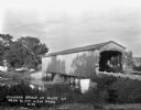
| Description: | View from shoreline of a covered bridge over a river. |

| Date: | 1912 |
|---|---|
| Description: | This outline map of Sauk County, Wisconsin, shows the towns, cities and villages, railroads, and streams in the county. |

| Date: | 1939 |
|---|---|
| Description: | This map of Sauk County, Wisconsin, shows the township and range grid, towns, sections, cities and villages, roads, railroads, lakes and rivers, schools, a... |
| Date: | 1975 |
|---|---|
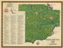
| Description: | This 1975 map of Sauk County, Wisconsin, lists and locates historic sites and other points of interest in the county. |

| Date: | 1990 |
|---|---|
| Description: | This late 20th century tourist map of Sauk County, Wisconsin, shows the highways and roads, cities and towns, parks, airports, canoe landings, hospitals, s... |

| Date: | 1915 |
|---|---|
| Description: | This 1915 map covers the section of the Wisconsin River in southern Adams, southeastern Juneau, northeastern Sauk, and northwestern Columbia counties. A po... |
| Date: | 1921 |
|---|---|
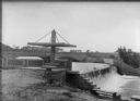
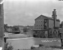
| Description: | View from shoreline over the Baraboo River towards a dam, with a mill on the opposite shoreline. A bridge and a business district are in the background. |

| Date: | 1909 |
|---|---|
| Description: | Elevated view of the Baraboo River. The main part of town is on the far left shoreline. On the right industrial buildings are near a bridge spanning the ri... |

| Date: | 1915 |
|---|---|
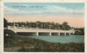
| Description: | Colorized postcard view of a bridge over a dam on a river. Trees are along both banks. Caption reads: "The High Bridge and Dam, Baraboo, Wis." |

| Date: | 1919 |
|---|---|
| Description: | Colorized postcard of an elevated view of a concrete bridge over a river. There is a boat near wooden pilings that stretch from the shoreline to the center... |
| Date: | 1938 |
|---|---|
| Description: | Colorized postcard view from shoreline of a stone bridge lined with lampposts. Dwellings and commercial buildings are on the far side. An elevated railroad... |
If you didn't find the material you searched for, our Library Reference Staff can help.
Call our reference desk at 608-264-6535 or email us at: