 Filter: Categories of Wisconsin Historical Images
Filter: Subject of Rivers
Filter: Year of 1900-1999
Filter: Subject of business
Filter: Categories of Wisconsin Historical Images
Filter: Subject of Rivers
Filter: Year of 1900-1999
Filter: Subject of business

| Date: | 1904 |
|---|---|
| Description: | A business map of Wisconsin also including the western portion of Michigan's Upper Peninsula, eastern Iowa and Minnesota, and northern Illinois, showing, r... |

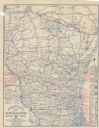
| Date: | 1910 |
|---|---|
| Description: | A business map of Wisconsin, showing railroads, counties, cities, villages, rivers, lakes, and electric lines. Additional areas also included in the map ar... |

| Date: | 1911 |
|---|---|
| Description: | A business atlas map of Wisconsin, showing the railroads, counties, cities, villages, rivers, lakes, electric lines, and steamship lines in the state. Othe... |

| Date: | 1964 |
|---|---|
| Description: | Shows local streets, bus routes, highways, airport, Dells Pond, Half Moon Lake, Chippewa River, and Eau Claire River. Includes 2 inset maps: Location map a... |

| Date: | 1926 |
|---|---|
| Description: | Relief shown by hachures. Shows local streets, roads, railroads, businesses, Half Moon Lake, Chippewa River, and log reservoir. |

| Date: | 1929 |
|---|---|
| Description: | This map is oriented with north to the upper right. Includes index of retailers and buildings, with some advertisements in margins. |

| Date: | 1916 |
|---|---|
| Description: | Includes index to businesses, churches, and schools. Shows local streets, buildings, railroads, ward divisions, Fond du Lac River, and part of Lake Winneba... |

| Date: | 1947 |
|---|---|
| Description: | This map of Wauwatosa shows 10 zoning class types of land including residential, manufacturing, and business. The map also shows government buildings, some... |

| Date: | 1940 |
|---|---|
| Description: | This map of Aztalan is pencil and ink on paper. The map shows streets, local businesses, churches, houses, and the Crawfish River. The map reads: "Informat... |

| Date: | 1950 |
|---|---|
| Description: | This map of Racine's business section is oriented with the north to the right and shows businesses and lot owners. Businesses, streets, and the Root River ... |

| Date: | 1964 |
|---|---|
| Description: | This map is a hand-colored blue line print and shows 4 residence zones, 2 business zones, 1 light manufacturing zones, schools, and parks. The zones are ou... |

| Date: | 1975 |
|---|---|
| Description: | This map shows plat of the city, city limits, local streets, and part of Baraboo River. The map includes 2 inset maps and a legend showing residential, bus... |

| Date: | 1917 |
|---|---|
| Description: | This map shows streets, land owners, local businesses, the St. Louis River, and bridges. The maps reads: "Incorporated 1917." The back of the map includes ... |

| Date: | 1910 |
|---|---|
| Description: | This map is a survey of Kenosha Harbor and shows local streets, public buildings, local businesses, and part of Lake Michigan. Included is text on sailing ... |

| Date: | 1987 |
|---|---|
| Description: | This pictorial map shows roads, bridges, local businesses with phone numbers, and public buildings. Relief is shown pictorially. Also included is a calen... |

| Date: | 1903 |
|---|---|
| Description: | This blue line print map is oriented with the north to the left and shows buildings with dimensions, utilities, and proposed buildings. The Flambeau River ... |

| Date: | 1914 |
|---|---|
| Description: | This photostat map shows Fort Winnebago around 1931, land to be reserved for military purposes, roads to Fort Howard and Fort Crawford, "private property" ... |

| Date: | 1900 |
|---|---|
| Description: | This map shows landownership, churches, schools, farm houses, wagon roads, railroads, and townships and includes businesses advertisements, tables of stati... |
| Date: | 1922 |
|---|---|
| Description: | This map shows roads, highways, lakes, rivers, county boundaries, and cities. Selected businesses are highlighted in red. Includes an explanation of state ... |
If you didn't find the material you searched for, our Library Reference Staff can help.
Call our reference desk at 608-264-6535 or email us at: