 Filter: Categories of Wisconsin Historical Images
Filter: Subject of Rivers
Filter: Year of 1900-1999
Filter: Subject of cities and towns
Filter: Year of 1970-1979
Filter: Categories of Wisconsin Historical Images
Filter: Subject of Rivers
Filter: Year of 1900-1999
Filter: Subject of cities and towns
Filter: Year of 1970-1979

| Date: | 07 05 1975 |
|---|---|
| Description: | The Tenney Park Bridge over the Yahara River. |

| Date: | 1970 |
|---|---|
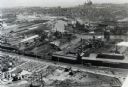
| Description: | Aerial view of International Harvester's Wisconsin Steel Works, with a river and Lake Michigan in the background. |
| Date: | 1970 |
|---|---|
| Description: | Aerial view of International Harvester's Wisconsin Steel Works (factory). |

| Date: | 1972 |
|---|---|
| Description: | Political scientist Samuel L. Popkin and his wife. This photograph was taken about the time Wisconsin-born Popkin was jailed for his refusal to testify abo... |
| Date: | 02 02 1978 |
|---|---|
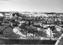
| Description: | "Water tower view, looking due west." |
| Date: | 02 02 1978 |
|---|---|
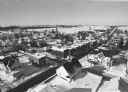
| Description: | "Groundhog Day... A view from the water tower, looking northwest. The 20mm lens provides a very wide angle of view." |

| Date: | 02 16 1978 |
|---|---|
| Description: | "The long lens compresses this view from the frozen Rock River in the foreground, the Catholic cemetery, and the Haag farm buildings in the distance." |

| Date: | 1972 |
|---|---|
| Description: | This map on 5 sheets features a title page sheet with business directory and shows section numbers, roads, railroads, saw mills, churches, blacksmith shops... |
| Date: | 1974 |
|---|---|
| Description: | A map that was originally published around 1851 in S. Augustus Mitchell's New universal atlas, shows portions of present-day Iron and Vilas counties north ... |
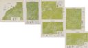
| Date: | 1975 |
|---|---|
| Description: | This series of six maps identifies land use in Taylor, Price, Rusk, Sawyer, Washburn, and Burnett counties based on data from 1966 through 1975. Each map i... |

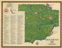
| Date: | 1975 |
|---|---|
| Description: | This map shows the locations of historic sites and points of interest in Rusk County, Wisconsin. A location key, descriptions of the historical importance ... |

| Date: | 1976 |
|---|---|
| Description: | An 1876 reprinted map of the Township of Franklin, Milwaukee County, Wisconsin, that shows the land ownership and sectioning of the town, as well as the ro... |

| Date: | 1976 |
|---|---|
| Description: | A street map of Milwaukee County, Wisconsin that identifies the location of schools, hospitals, parks, beaches, streets, freeways, both planned or under co... |
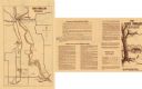
| Date: | 1975 |
|---|---|
| Description: | This 1975 map of Sauk County, Wisconsin, lists and locates historic sites and other points of interest in the county. |

| Date: | 1974 |
|---|---|
| Description: | This 1974 map is a reproduction of the original survey maps of the Four Lakes region of Dane County, Wisconsin. It shows sections, lakes, rivers, wetlands,... |
| Date: | 1974 |
|---|---|
| Description: | This 1974 map shows historical sites related to Caddie Woodlawn, a book by Carol Ryrie Brink, in the Town of Dunn, Dunn County, Wisconsin. Some landmarks a... |

| Date: | 1972 |
|---|---|
| Description: | Ink on tracing paper. This map shows rivers, Prairie du Chien, site of Fort Crawford, Excelsior, Fort Andrew, Boscobel, Blue River, Orion, Muscoda, Castle ... |

| Date: | 1970 |
|---|---|
| Description: | Elevated view of an International Harvester model MA-1500 Metro delivery truck is parked on a bridge overlooking a body of water and a city skyline, likely... |

| Date: | 1970 |
|---|---|
| Description: | Color coded map. Legend in the top left hand corner reads: "EXISTING AIRPORT PAVEMENT" (purple), "FUTURE 5-YEAR DEVELOPMENT" (bright pink), "ULTIMATE AIRPO... |
If you didn't find the material you searched for, our Library Reference Staff can help.
Call our reference desk at 608-264-6535 or email us at:
