 Filter: Categories of Wisconsin Historical Images
Filter: Subject of Rivers
Filter: Year of 1900-1999
Filter: Subject of fortification
Filter: Categories of Wisconsin Historical Images
Filter: Subject of Rivers
Filter: Year of 1900-1999
Filter: Subject of fortification

| Date: | 1936 |
|---|---|
| Description: | This map is red and black ink on tracing cloth and is oriented with north to the upper left. This hand-drawn map shows a central portion of the military ro... |
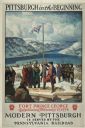
| Date: | 1930 |
|---|---|
| Description: | An original lithograph promoting Pittsburgh, Pennsylvania, and the Pennsylvania Railroad through artist N.C. Wyeth's depiction of the establishment of Fort... |

| Date: | 1941 |
|---|---|
| Description: | This pictorial map of Wisconsin with historical text highlights the history of the state and identifies places of interest, Indian villages, missions, trad... |

| Date: | 1914 |
|---|---|
| Description: | This map is a photostat copy from the original 1829 map in the War Department. The map shows location of Fort Howard, lots, land claims of Jacques Porlier ... |

| Date: | 1911 |
|---|---|
| Description: | This hand-colored map is a 1911 copy of a map drawn by Gaspard-Joseph Chaussegros de Léry in 1730 showing the Fox River from its mouth at Green Bay to Lake... |

| Date: | 1972 |
|---|---|
| Description: | Ink on tracing paper. This map shows rivers, Prairie du Chien, site of Fort Crawford, Excelsior, Fort Andrew, Boscobel, Blue River, Orion, Muscoda, Castle ... |

| Date: | 1918 |
|---|---|
| Description: | Outdoor view of a U.S. Army Engineer topographer wearing skis while using a tripod stand to write. The engineer is standing next to a barbed wire obstacle ... |

| Date: | 1900 |
|---|---|
| Description: | This map of Green Bay shows plat of the town, lots by number, local streets, the military Fort Howard, part of Fox River and part of Navarino. The map feat... |

| Date: | 1900 |
|---|---|
| Description: | This map of West Navarino shows plat of the town, lots by number, local streets, public square, The Fox River, and Fort Howard. The bottom of the map reads... |

| Date: | 1930 |
|---|---|
| Description: | This map shows a plat of the town, local streets, railroads, creeks, part of Fox River, and part of the bay of Green Bay. The location of the original fort... |

| Date: | 1900 |
|---|---|
| Description: | This photocopied map shows private claim owners, buildings, and land use in 1818. Insets show Fort Howard and the caption reads: "A view of the Fox River ... |

| Date: | 1960 |
|---|---|
| Description: | This map is a facsimile of a 1829 map and shows private land claims, landowners within military reserve boundaries, sawmill, Fort Howard, public barns, bri... |

| Date: | 1950 |
|---|---|
| Description: | This map shows regions in Northern Illinois and Southern Wisconsin roughly bounded by Lake Winnebago, the Kankakee River, Peoria, and Prairie du Chien. The... |

| Date: | 1900 |
|---|---|
| Description: | This map shows a proposed route of for a road linking military forts. The map also includes communities, lakes, and rivers. The map is accompanied by a rep... |

| Date: | 1900 |
|---|---|
| Description: | This map shows the boundary lines between ceded and unceded land in compliance with the Treaty of Prairie du Chen of 1829. It also shows roads, rivers, por... |

| Date: | 1914 |
|---|---|
| Description: | This photostat map shows Fort Winnebago around 1931, land to be reserved for military purposes, roads to Fort Howard and Fort Crawford, "private property" ... |

| Date: | 1900 |
|---|---|
| Description: | This map shows portion of the military road from Fond du Lac to the Wisconsin River near Fort Winnebago, with mile markers and adjacent land use. A few pro... |

| Date: | 1929 |
|---|---|
| Description: | This map with north oriented to the upper left shows military forts, Indian villages, settler's houses with surnames, trading houses, lodges and encampment... |

| Date: | 1900 |
|---|---|
| Description: | This manuscript map shows outline of Fort Winnebago reserve land, Fort Winnebago, claim of A. Grignon, and Indian boundaries. The Fox River and Swan Lake a... |

| Date: | 1900 |
|---|---|
| Description: | This photocopy map shows marshes, woods, buildings, and selected features including islands, mounds, old Fort Crawford, and "new site for a fort in questio... |
If you didn't find the material you searched for, our Library Reference Staff can help.
Call our reference desk at 608-264-6535 or email us at: