 Filter: Categories of Wisconsin Historical Images
Filter: Subject of Rivers
Filter: Year of 1900-1999
Filter: Subject of human settlements
Filter: Community of Eau Claire
Filter: Categories of Wisconsin Historical Images
Filter: Subject of Rivers
Filter: Year of 1900-1999
Filter: Subject of human settlements
Filter: Community of Eau Claire

| Date: | 1930 |
|---|---|
| Description: | Aerial view of Carson Park, Half Moon Lake and part of the West Side in the foreground. The municipal bath house is on the lake shore in the foreground. A ... |

| Date: | 1930 |
|---|---|
| Description: | Aerial view of city, with Eau Claire River is in the foreground with Milwaukee railroad bridge at left. Gillette Rubber Co. plant is in center with Omaha r... |

| Date: | 1931 |
|---|---|
| Description: | Aerial view looking north, with a small portion of the West Side (left), nearly all of the North Side and part of the business district of the East Side. A... |
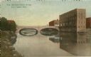
| Date: | 1905 |
|---|---|
| Description: | View of the bridge. Caption reads: "New Barstow Street Bridge Eau Claire, Wis." |
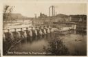
| Date: | 1930 |
|---|---|
| Description: | Elevated view of the dam and the mill, with some trees in the foreground. A railroad bridge is in the background on the left, and a rail cart or truck is d... |
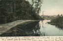
| Date: | 1905 |
|---|---|
| Description: | Little Niagara River, with multiple buildings in the background. Caption reads: "Little Niagara, Eau Claire, Wisc." |
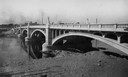
| Date: | 1930 |
|---|---|
| Description: | Madison Street Bridge, built in about 1925. View from shoreline across river with the bridge on the right. |
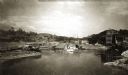
| Date: | 1900 |
|---|---|
| Description: | View up the Eau Claire River from the Dewey Street Bridge. The view shows the dam and linen mill and the site of the lower sawmill (called the "steam mill"... |

| Date: | 1906 |
|---|---|
| Description: | Elevated view of downtown Eau Claire. |
| Date: | 1930 |
|---|---|
| Description: | Carson Park on the Chippewa River, with the entrance to a tunnel which was used to transport logs from the river into Half Moon Lake. |

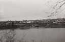
| Date: | 1900 |
|---|---|
| Description: | Elevated view of the Chippewa River and downtown Eau Claire. |

| Date: | 1944 |
|---|---|
| Description: | Aerial view of the U.S. Rubber Company plant and surrounding environment. |

| Date: | 1964 |
|---|---|
| Description: | An aerial view of the U.S. Rubber Company plant and surrounding environment. |

| Date: | 1964 |
|---|---|
| Description: | An aerial view of the U.S. Rubber Company plant and surrounding environment. |
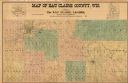
| Date: | 1902 |
|---|---|
| Description: | This 1902 map of Eau Claire County, Wisconsin, shows the township and range grid, towns, sections, landownership and acreages, roads and railroads, and sel... |
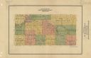
| Date: | 1911 |
|---|---|
| Description: | Map shows townships and sections, roads, and railroads. "W.W. Downs, attorney-at-law, Eau Claire, Wis." |

| Date: | 1964 |
|---|---|
| Description: | Shows local streets, bus routes, highways, airport, Dells Pond, Half Moon Lake, Chippewa River, and Eau Claire River. Includes 2 inset maps: Location map a... |
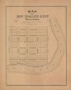
| Date: | 1900 |
|---|---|
| Description: | Shows plat of town, local streets, town sections, and Chippewa River. Streets running horizontally begin at the top with "Lake Street" and end with "Water ... |

| Date: | 1926 |
|---|---|
| Description: | Relief shown by hachures. Shows local streets, roads, railroads, businesses, Half Moon Lake, Chippewa River, and log reservoir. |

| Date: | 1918 |
|---|---|
| Description: | This map has relief shown by hachures and is indexed by street name and buildings. The map shows plat of town, city limits, local streets, railroads, schoo... |
If you didn't find the material you searched for, our Library Reference Staff can help.
Call our reference desk at 608-264-6535 or email us at: