Filter: Categories of Wisconsin Historical Images
Filter: Subject of Rivers
Filter: Year of 1900-1999
Filter: Subject of land use, rural
Filter: Categories of Wisconsin Historical Images
Filter: Subject of Rivers
Filter: Year of 1900-1999
Filter: Subject of land use, rural
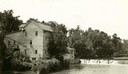
| Date: | 1920 |
|---|---|
| Description: | A large building, possibly a mill, next to a river. |

| Date: | 05 31 1965 |
|---|---|
| Description: | Elevated view of Evangelical United Brethren church in the vicinity of Highway T. |
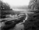
| Date: | 08 13 1961 |
|---|---|
| Description: | A Wisconsin River swamp. The swampy area is framed by trees with more trees in the background hidden by fog. |
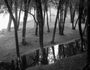
| Date: | 09 22 1962 |
|---|---|
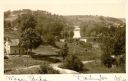
| Description: | Elevated view of trees and pool of water near the Wisconsin River in Pauquette Park. |

| Date: | 1910 |
|---|---|
| Description: | Map of Dane County rural delivery in Madison and the town of Westport. |
| Date: | 1910 |
|---|---|
| Description: | View of the Crawfish River in the vicinity of Aztalan. |

| Date: | 1955 |
|---|---|
| Description: | Aerial view of town, with the Baraboo River. |
| Date: | 1900 |
|---|---|
| Description: | Elevated view of wagon bridge in Darlington, with a river on the right, a cow in a field, and a building on the left. |
| Date: | 1905 |
|---|---|
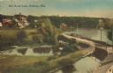
| Description: | Elevated view of a pond, a stream, and a lake, with a road dividing the pond and stream from the lake. Industrial buildings and a smokestack are in the bac... |
| Date: | 1900 |
|---|---|
| Description: | A woman stands in a marsh near the site of Eleazer William's first house. |
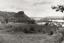
| Date: | 1953 |
|---|---|
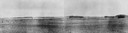
| Description: | View across fields towards the Genoa Dam on the Mississippi River. Tree-covered hills are on the left. |
| Date: | 1934 |
|---|---|
| Description: | Aerial view of the Jones dairy farm, Fort Atkinson, in winter. The Rock River is in the background. |

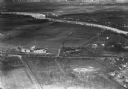
| Date: | 11 1928 |
|---|---|
| Description: | Aerial view of Stoughton, including the central business district, residential areas, the Yahara River, and the surrounding countryside. |

| Date: | 1930 |
|---|---|
| Description: | Aerial view of Lake Delton, the Wisconsin River, and the surrounding countryside. |

| Date: | 04 1959 |
|---|---|
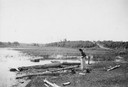
| Description: | The Mississippi River Logging Company's railroad grade two miles south of Weyerhaeuser over Soft Maple Creek, built about 1875-76. |

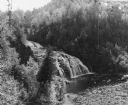
| Date: | 04 1959 |
|---|---|
| Description: | The Mississippi River Logging Company's dam built in Soft Maple Creek in 1877. |

| Date: | 04 1959 |
|---|---|
| Description: | The Mississippi River Logging Company's dam built in Soft Maple Creek in 1877. |
If you didn't find the material you searched for, our Library Reference Staff can help.
Call our reference desk at 608-264-6535 or email us at: