 Filter: Categories of Wisconsin Historical Images
Filter: Subject of Rivers
Filter: Year of 1900-1999
Filter: Subject of marshes
Filter: Categories of Wisconsin Historical Images
Filter: Subject of Rivers
Filter: Year of 1900-1999
Filter: Subject of marshes
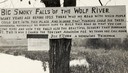
| Date: | 1920 |
|---|---|
| Description: | Sign for the toll road at Big Smoky Falls on the Wolf River. The sign reads: "Big Smoky Falls of the Wolf River. Many years ago before 1925 there was no ro... |
| Date: | 1900 |
|---|---|
| Description: | A woman stands in a marsh near the site of Eleazer William's first house. |

| Date: | 1925 |
|---|---|
| Description: | The Pierre Pauquette monument located at the easterm terminus of the Wauona Trail. Erected by the Wau-bun Chapter of the Daughters of the American Revoluti... |

| Date: | 1972 |
|---|---|
| Description: | This map on 5 sheets features a title page sheet with business directory and shows section numbers, roads, railroads, saw mills, churches, blacksmith shops... |

| Date: | 1968 |
|---|---|
| Description: | This map is ink and color on printed grid. Shows geology, portage trails, timber type, some landownership, hydrology, and marshes in part of Florence Count... |

| Date: | 1975 |
|---|---|
| Description: | This standard U.S.G.S. topographic map was annotated by civil engineer and railroad historian James P. Kaysen to show the location of existing and defunct ... |

| Date: | 1911 |
|---|---|
| Description: | This map shows lakes, rivers, swamps, state swamp land, trails and railroads. Includes a township diagram. |

| Date: | 1951 |
|---|---|
| Description: | This map shows land use, dwellings, resorts, camps, marshes, springs, dams, lake bottom composition, and access. The map includes a fish species table, geo... |

| Date: | 1900 |
|---|---|
| Description: | This map shows portion of the military road from Fond du Lac to the Wisconsin River near Fort Winnebago, with mile markers and adjacent land use. A few pro... |

| Date: | 1931 |
|---|---|
| Description: | This map shows heavy industrial districts (yellow), commercial and light manufacturing districts (red), and residential districts (white) as well as a plat... |
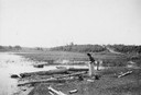
| Date: | 1907 |
|---|---|
| Description: | Four boats are partially submerged in shallow water by the St. Croix River. |

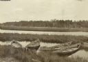
| Date: | 08 1916 |
|---|---|
| Description: | Elevated view looking down at a canoe on the shoreline of the Chippewa River as The Gang takes a well-earned rest. |

| Date: | 1971 |
|---|---|
| Description: | A topographical map of the Grand View NW quadrangle. |

| Date: | 10 04 1906 |
|---|---|
| Description: | A man is sitting on a rock by a river's edge under trees. Vicinity of Chicago. |

| Date: | 1905 |
|---|---|
| Description: | View from shoreline looking towards two women wearing large hats who are sitting in a carriage drawn by a matched team of horses. The carriage has stopped ... |
If you didn't find the material you searched for, our Library Reference Staff can help.
Call our reference desk at 608-264-6535 or email us at:
