 Filter: Categories of Wisconsin Historical Images
Filter: Subject of Rivers
Filter: Year of 1900-1999
Filter: Subject of military camps
Filter: Categories of Wisconsin Historical Images
Filter: Subject of Rivers
Filter: Year of 1900-1999
Filter: Subject of military camps
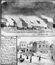
| Date: | 11 08 1906 |
|---|---|
| Description: | Two Civil War watercolor drawings by John Gaddis, Company E, 12th Wisconsin Volunteer Infantry, showing the regiment in bivouac, and later their headquarte... |

| Date: | 1912 |
|---|---|
| Description: | This map from the U.S. General Land Office shows railroads, counties, cities and villages, rivers, lakes, U.S. Land Offices, Indian reservations, military ... |

| Date: | 1931 |
|---|---|
| Description: | A topographical map from the U.S. Army Corp of Engineers showing the topography and man-made features in the Camp Williams area of the towns of Orange and ... |

| Date: | 1900 |
|---|---|
| Description: | This map shows portion of the military road from Fond du Lac to the Wisconsin River near Fort Winnebago, with mile markers and adjacent land use. A few pro... |
If you didn't find the material you searched for, our Library Reference Staff can help.
Call our reference desk at 608-264-6535 or email us at: