Filter: Categories of Wisconsin Historical Images
Filter: Subject of Rivers
Filter: Year of 1900-1999
Filter: Subject of neighborhoods
Filter: Categories of Wisconsin Historical Images
Filter: Subject of Rivers
Filter: Year of 1900-1999
Filter: Subject of neighborhoods
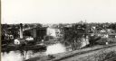
| Date: | 1908 |
|---|---|
| Description: | The Yahara River from Williamson Street with Lake Monona in the background. House & Barn pictured is located at 601 Riverside Drive. |
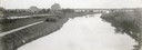
| Date: | 1908 |
|---|---|
| Description: | A view of the Yahara River below Williamson Street. |
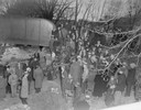
| Date: | 03 23 1934 |
|---|---|
| Description: | Crowd standing on the Thornton Avenue bank of the Yahara River at the Milwaukee Road railroad bridge looking at a car-train accident scene where Mrs. Clark... |
| Date: | 03 23 1934 |
|---|---|
| Description: | Crowd standing on the Thornton Avenue bank of the Yahara River at the Milwaukee Road railroad bridge looking at a car-train accident scene where Mrs. Clark... |
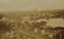
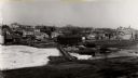
| Date: | 1900 |
|---|---|
| Description: | Elevated view over houses towards the industrial area along the Rock River. |
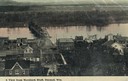
| Date: | 1900 |
|---|---|
| Description: | Elevated view of Durand. A street in the foreground leads to a bridge that crosses the river. Caption reads: "A View from Morsbach Bluff, Durand, Wis." |
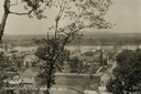
| Date: | 1910 |
|---|---|
| Description: | Elevated view from hill of Durand through trees, with houses in the foreground, and the river and hills in the background. Taken in the summer, with wash o... |

| Date: | 1930 |
|---|---|
| Description: | Aerial view of Carson Park, Half Moon Lake and part of the West Side in the foreground. The municipal bath house is on the lake shore in the foreground. A ... |

| Date: | 1930 |
|---|---|
| Description: | Aerial view of city, with Eau Claire River is in the foreground with Milwaukee railroad bridge at left. Gillette Rubber Co. plant is in center with Omaha r... |

| Date: | 1950 |
|---|---|
| Description: | Aerial view of fields near neighborhoods. |

| Date: | 1930 |
|---|---|
| Description: | Aerial view of Tenney Park, including the lagoon, residences surrounding the park, and the shoreline of Lake Mendota on bottom left. |

| Date: | 1908 |
|---|---|
| Description: | Elevated view of Wauzeka. A bridge over a river is in the background. |
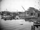
| Date: | 10 28 1938 |
|---|---|
| Description: | Docks and shanties at Jones Island, with smokestacks and cranes in the background. |
| Date: | 1900 |
|---|---|
| Description: | View of Mayville behind the frozen, snow-covered river. |

| Date: | 1920 |
|---|---|
| Description: | View down the river at night. Caption reads: "River View at Night, Menasha, Wis." |

| Date: | 06 18 1945 |
|---|---|
| Description: | Four people fishing from the Westport bridge. Six people have lost their lives within the past eight weeks at this bridge. |
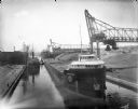
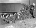
| Date: | 07 17 1914 |
|---|---|
| Description: | Menominee River coal yards, west from the 16th Street viaduct. There is a cargo ship called the "John B. Cowle" in the harbor between two coal yards. Worke... |
If you didn't find the material you searched for, our Library Reference Staff can help.
Call our reference desk at 608-264-6535 or email us at: