Filter: Categories of Wisconsin Historical Images
Filter: Subject of Rivers
Filter: Year of 1900-1999
Filter: Subject of persons
Filter: Categories of Wisconsin Historical Images
Filter: Subject of Rivers
Filter: Year of 1900-1999
Filter: Subject of persons
| Date: | 1911 |
|---|---|
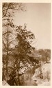
| Description: | Winter scene with stream and snow-covered trees, probably near Taliesin, the home of Frank Lloyd Wright. Wright dammed the stream to supply water to Talie... |
| Date: | 1918 |
|---|---|
| Description: | View of waterfall, bridge, Baraboo river, and town from the riverbank. |

| Date: | 1905 |
|---|---|
| Description: | Cover of an advertising catalog for International Harvester's line of Osborne harvesting machinery. The color illustration shows a man and a woman standing... |
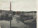
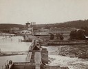
| Date: | 1905 |
|---|---|
| Description: | View of the dam and power plant over the river, with smokestacks in the background. Caption reads: "The Dam, Beloit, Wis." |
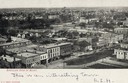
| Date: | 1900 |
|---|---|
| Description: | Elevated view of downtown. Caption reads: "Bird's-eye view of Beloit." |
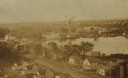
| Date: | 1900 |
|---|---|
| Description: | Elevated view over houses towards the industrial area along the Rock River. |
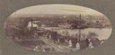
| Date: | 1900 |
|---|---|
| Description: | Oval-framed view of the industrial area along the Rock River. |
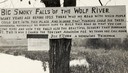
| Date: | 1920 |
|---|---|
| Description: | Sign for the toll road at Big Smoky Falls on the Wolf River. The sign reads: "Big Smoky Falls of the Wolf River. Many years ago before 1925 there was no ro... |
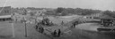
| Date: | 1923 |
|---|---|
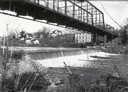
| Description: | Elevated view of a bridge over the Black River during construction. It was built during 1923 and 1924 by the Wausau Iron Works. Tom Cleary was the Resident... |
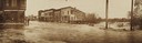
| Date: | 1911 |
|---|---|
| Description: | View of Main and Water Streets while experiencing severe flooding. |
| Date: | 1900 |
|---|---|
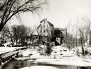
| Description: | View of the Wausau mill and dam next to the river, where logs were first sorted. |

| Date: | 1930 |
|---|---|
| Description: | View of bridge and Brule River monument. Placed where the Brule River is crossed by the Memorial Highway from Superior to Brule and Ashland (Highway 2). |
| Date: | 1948 |
|---|---|
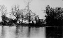
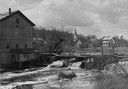
| Description: | Elevated view from shoreline towards the opposite shoreline towards the Buettner mill on the left, and the river with a dam, on the right. In the backgroun... |
| Date: | 1930 |
|---|---|
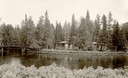
| Description: | Cedar Island on Brule River, a nationally known speckle trout stream. The island has native towering white pine and bubbling clear springs. These are some ... |
| Date: | 1934 |
|---|---|
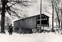
| Description: | Southwest view of a covered bridge over Cedar Creek, with a man walking in the snow nearby. |
| Date: | 1957 |
|---|---|
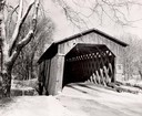
| Description: | Covered bridge over Cedar Creek in Ozaukee County on highway, about one mile north of Cedarburg. The last remaining covered bridge in Wisconsin. Snow is on... |
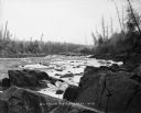
| Date: | 1900 |
|---|---|
| Description: | Big Falls, looking down the Flambeau River. There are large boulders in the foreground and patches of ice in the river. Caption at bottom reads: "Big Falls... |
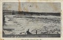
| Date: | 1910 |
|---|---|
| Description: | Chippewa falls and dam. Caption reads: "Falls and Dam, Chippewa Falls, Wis." |
If you didn't find the material you searched for, our Library Reference Staff can help.
Call our reference desk at 608-264-6535 or email us at: