Filter: Categories of Wisconsin Historical Images
Filter: Subject of Rivers
Filter: Year of 1900-1999
Filter: Subject of rural areas
Filter: Categories of Wisconsin Historical Images
Filter: Subject of Rivers
Filter: Year of 1900-1999
Filter: Subject of rural areas

| Date: | 1951 |
|---|---|
| Description: | Aerial view of the Nekoosa-Edwards Paper Company nursery. |
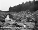
| Date: | 1900 |
|---|---|
| Description: | Panoramic view of the Wisconsin River in the Wisconsin Dells from underneath an overhanging rocky outcropping. A canoe is beached on the far left. The word... |
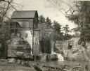
| Date: | 1948 |
|---|---|
| Description: | Abandoned mill, formerly called the Modena Roller Mills. The first mill was built in 1865 (now torn down). |
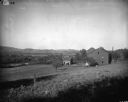
| Date: | 1900 |
|---|---|
| Description: | Rural scene of farmstead with a river or stream (?) in the background. The farm is bounded by a barbed wire fence, and there is a utility pole on the bank ... |
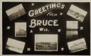
| Date: | 05 15 1909 |
|---|---|
| Description: | Photographic postcard of a poster promoting Bruce with seven photographs. The fairgrounds, Main Street, farm scene, Catholic Church, Chippewa River bridge,... |
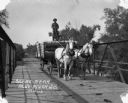
| Date: | 1913 |
|---|---|
| Description: | A man drives a team of horses pulling a wagon across a bridge. The man is standing atop the barreled goods, holding the reins. There is dung on the road. |

| Date: | 06 1962 |
|---|---|
| Description: | Aerial view of old U.S. Army model H-21 helicopter, assigned to help Vietnamese forces fight the Viet Cong in the mountain region of Vietnam. The patchwork... |

| Date: | 05 1962 |
|---|---|
| Description: | Vietnamese Rangers escort a newly captured prisoner suspected of being Viet Cong down a gravel road in the vicinity of Bac Lien, Vietnam. The prisoner has ... |
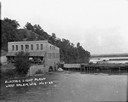
| Date: | 1922 |
|---|---|
| Description: | Elevated view across water of a stone building next to an earthen dam on the La Crosse River. There is an archway on the side of the building at the river ... |

| Date: | 1919 |
|---|---|
| Description: | Colorized postcard of an elevated view of a concrete bridge over a river. There is a boat near wooden pilings that stretch from the shoreline to the center... |
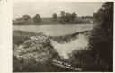
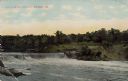
| Date: | 1910 |
|---|---|
| Description: | View of a river with a dam waterfall. A road runs along the far side of the river, and a large barn is across the road on the right. Caption reads: "Scenic... |
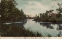
| Date: | 1910 |
|---|---|
| Description: | Colorized postcard view of a river scene and neighboring farm. Caption reads: "Scenic View on Milwaukee River, near Campbellsport, Wis." |

| Date: | 1901 |
|---|---|
| Description: | View along the Catfish River, with shrubs and grasses covering the riverbank. On the far left are electrical poles along a dirt road bordering a field that... |

| Date: | 08 1960 |
|---|---|
| Description: | This map shows a detailed account of southwestern Wisconsin. Individual settlers, the type of trees that grow in given areas, the quality of the soil (labe... |
| Date: | 1900 |
|---|---|
| Description: | This map shows the distances and land use and type along the road from Green Bay to Racine. A few places are labeled, including Devil River, Sheboygan Rive... |
| Date: | 1900 |
|---|---|
| Description: | This map shows distances, land use, and landowners along the road from Racine to Janesville. The map is divided into several sheets with north typically or... |
| Date: | 1911 |
|---|---|
| Description: | Colorized photograph of a dam on the Eau Claire River, Eau Claire, Wisconsin. Caption reads: "Dam on the Eau Claire River, Eau Claire, Wis." |

| Date: | 1907 |
|---|---|
| Description: | Elevated view from hill towards the Fox River, with a farm in the foreground. The farm has a windmill with a sign on it that reads: "Kilbourn Steel Mill," ... |
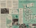
| Date: | 1953 |
|---|---|
| Description: | This map shows the locations of many scenic areas in La Crosse, Vernon, Crawford, Richland, Grant, and Iowa Counties. On the front side of the map, there i... |
If you didn't find the material you searched for, our Library Reference Staff can help.
Call our reference desk at 608-264-6535 or email us at: