 Filter: Categories of Wisconsin Historical Images
Filter: Subject of Rivers
Filter: Year of 1900-1999
Filter: Subject of shipping
Filter: Categories of Wisconsin Historical Images
Filter: Subject of Rivers
Filter: Year of 1900-1999
Filter: Subject of shipping
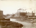
| Date: | 1900 |
|---|---|
| Description: | Southeast panorama of the McCormick Reaper Works, rail yard and canal. The factory was owned by the McCormick Harvesting Machine company before 1902. In 19... |
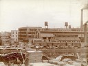
| Date: | 1900 |
|---|---|
| Description: | Workers loading and unloading wood at the wood stock yard of the McCormick Reaper Works. Men are working on both sides of the Chicago River. Rail cars and ... |

| Date: | 1920 |
|---|---|
| Description: | Elevated view of ships sailing up the Fox River alongside the coal yards located in Green Bay. |

| Date: | 1910 |
|---|---|
| Description: | Slightly elevated view of the Fox River, with a bridge and ship in the river. |
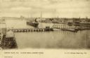
| Date: | 1900 |
|---|---|
| Description: | Looking North. Harbor with boats, bridge, and buildings. |

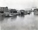
| Date: | 1910 |
|---|---|
| Description: | Elevated view of freighters lined up along the river. Caption reads: "Freighters, Menomonee River, Milwaukee, Wis." |

| Date: | 1910 |
|---|---|
| Description: | Elevated view of downtown. Part of the Milwaukee River is on the left side. Sign for the Germania building is in the lower right, and city hall is in the b... |
| Date: | 1938 |
|---|---|
| Description: | Elevated view of a boat owned by Julius Dettloff docked along the edge of a river. The boat was powered by an International PD-40 power unit; in the backgr... |

| Date: | 1902 |
|---|---|
| Description: | Two panoramic bird's-eye views of the Paine Lumber Company, including the general plant, sawmill, and lumber yards. Heading at the top says: Home of Wiscon... |

| Date: | 1951 |
|---|---|
| Description: | This map of Superior shows labeled streets, waterways, railroads, and company ownership of docks. |

| Date: | 1932 |
|---|---|
| Description: | This map of Superior shows many points of interests including camping, fair grounds, docks, tourist attractions, lakes, roads, and waterways. |

| Date: | 01 08 1958 |
|---|---|
| Description: | Elevated view from 8th Street Bridge over the Manitowoc River towards Lake Michigan. There is a lighthouse in the distance. Ice is floating on the water. A... |
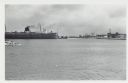
| Date: | 01 07 1958 |
|---|---|
| Description: | View across water to ship moored at a dock. Smoke is coming out of the smokestack. Industrial buildings are across the water on the right. |
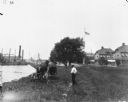
| Date: | 1900 |
|---|---|
| Description: | View from rear of a man using a horse-drawn mower along a shoreline at League Island. A man is standing near him on the right. In the background on the lef... |

| Date: | 1902 |
|---|---|
| Description: | This map is a chart of Milwaukee Harbor that displays local streets, bridges, roads, railroads, public buildings, businesses, factories, dry docks, parks, ... |
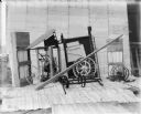
| Date: | 1900 |
|---|---|
| Description: | Corn binder dismantled for shipping. Some parts are crated. There is a white sheet behind the corn binder serving as a backdrop, and railroad tracks run al... |
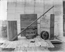
| Date: | 1900 |
|---|---|
| Description: | Binder dismantled for shipping. There is a white sheet behind the crates serving as a backdrop. In the background on the left are railroad tracks running a... |

| Date: | 1923 |
|---|---|
| Description: | This map includes an explanation that reads: "This chart shows the movement of barley on the Great Lakes, St. Lawrence River, and New York State Barge Cana... |

| Date: | 1923 |
|---|---|
| Description: | This map includes an explanation that reads: "This chart shows the movement of corn on the Great Lakes, St. Lawrence River, and New York State Barge Canal ... |

| Date: | 1923 |
|---|---|
| Description: | This map includes an explanation that reads: "This chart shows the easterly movement of flaxseed on the Great Lakes, St. Lawrence River, and New York State... |
If you didn't find the material you searched for, our Library Reference Staff can help.
Call our reference desk at 608-264-6535 or email us at: