 Filter: Categories of Wisconsin Historical Images
Filter: Subject of Rivers
Filter: Year of 1900-1999
Filter: Subject of streets
Filter: Categories of Wisconsin Historical Images
Filter: Subject of Rivers
Filter: Year of 1900-1999
Filter: Subject of streets

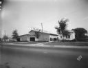
| Date: | 1907 |
|---|---|
| Description: | Buildings and storefronts in town near bridge and river. |

| Date: | 1914 |
|---|---|
| Description: | This map shows Sheboygan in 1914. The top of the map has the date of "NOV 17 1916" stamped in red ink. The map shows numbered plots and labeled streets, an... |
| Date: | 09 19 1928 |
|---|---|
| Description: | Marling Lumber Company, 1801 East Washington Avenue. The Yahara River is to the right, with a bridge in the background. |

| Date: | 1937 |
|---|---|
| Description: | Bird's-eye view of Milwaukee in 1853 details building features and city layout from southwest. Important buildings are numbered in a silhouette drawing bel... |
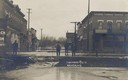
| Date: | 03 16 1919 |
|---|---|
| Description: | View showing the flood conditions on city streets from the 1919 Flood on the Trempealeau River. Four men are surveying the damage. Caption reads: "Highwate... |

| Date: | 1950 |
|---|---|
| Description: | Map showing buildings formerly used as Ringling Brothers Circus winter quarters, along with adjoining buildings. |
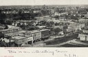
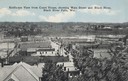
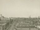
| Date: | 1900 |
|---|---|
| Description: | Elevated view of downtown. Caption reads: "Bird's-eye view of Beloit." |
| Date: | 1900 |
|---|---|
| Description: | Elevated view over houses towards the industrial area along the Rock River. |
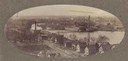
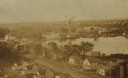
| Date: | 1900 |
|---|---|
| Description: | Oval-framed view of the industrial area along the Rock River. |

| Date: | 1965 |
|---|---|
| Description: | Aerial view of downtown Big Falls and the Little Wolf River. The Little Wolf River is at lower right. |
| Date: | 1915 |
|---|---|
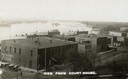
| Description: | Elevated view from the Court House. Hills are in the distance. Caption reads: "Bird's-eye View from Court House, showing Main Street and Black River, Black... |
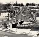
| Date: | 1959 |
|---|---|
| Description: | Elevated view of street with bridge in Darlington. Cars are parked in the center of the street at an angle. |
| Date: | 1935 |
|---|---|
| Description: | Elevated view of Darlington, with the bridge over the river in the foreground, and the town beyond. Caption reads: "View from the Hill, Darlington, Wis." |
| Date: | 1910 |
|---|---|
| Description: | Elevated view of commercial buildings along the river from the vantage point of the Court House. Horse-drawn carriages and pedestrians are along the street... |
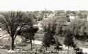
| Date: | 1900 |
|---|---|
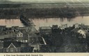
| Description: | Elevated view of Durand. A street in the foreground leads to a bridge that crosses the river. Caption reads: "A View from Morsbach Bluff, Durand, Wis." |
| Date: | 1910 |
|---|---|
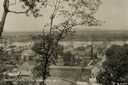
| Description: | Elevated view from hill of Durand through trees, with houses in the foreground, and the river and hills in the background. Taken in the summer, with wash o... |

| Date: | 1900 |
|---|---|
| Description: | Elevated view of the Chippewa River and downtown Eau Claire. |
| Date: | 1910 |
|---|---|
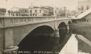
| Description: | View of a river and Main Street bridge above the river. Commercial buildings line the street on the opposite side of the bridge. Caption reads: "Main St. B... |
| Date: | 1920 |
|---|---|
| Description: | Elevated view of the commercial area along the east side of the Fox River. |
If you didn't find the material you searched for, our Library Reference Staff can help.
Call our reference desk at 608-264-6535 or email us at:
