Filter: Categories of Wisconsin Historical Images
Filter: Subject of Rivers
Filter: Year of 1900-1999
Filter: Subject of transportation
Filter: County of Dane
Filter: Categories of Wisconsin Historical Images
Filter: Subject of Rivers
Filter: Year of 1900-1999
Filter: Subject of transportation
Filter: County of Dane
| Date: | 1908 |
|---|---|
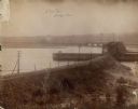
| Description: | The Yahara River from Williamson Street with Lake Monona in the background. House & Barn pictured is located at 601 Riverside Drive. |
| Date: | 1908 |
|---|---|
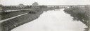
| Description: | A view of the Yahara River below Williamson Street. |

| Date: | 1910 |
|---|---|
| Description: | Map of Dane County rural delivery in Madison and the town of Westport. |

| Date: | 1910 |
|---|---|
| Description: | Map of the general plan of the district of the Four Lakes. |
| Date: | 1904 |
|---|---|
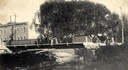
| Description: | View across Yahara River towards a group of people on the Sherman Avenue Bridge, with the old malt house in the background. |

| Date: | 04 18 1935 |
|---|---|
| Description: | Miss Pyre standing next to a Ford V-8 coupe near a bridge at Tenney Park. A building with a tower is in the background, perhaps the Hausmann Brewing Compan... |
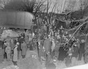
| Date: | 03 23 1934 |
|---|---|
| Description: | Crowd standing on the Thornton Avenue bank of the Yahara River at the Milwaukee Road railroad bridge looking at a car-train accident scene where Mrs. Clark... |
| Date: | 03 23 1934 |
|---|---|
| Description: | Crowd standing on the Thornton Avenue bank of the Yahara River at the Milwaukee Road railroad bridge looking at a car-train accident scene where Mrs. Clark... |
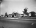
| Date: | 09 19 1928 |
|---|---|
| Description: | Marling Lumber Company, 1801 East Washington Avenue. The Yahara River is to the right, with a bridge in the background. |

| Date: | 1956 |
|---|---|
| Description: | Aerial view looking northeast from a point over the east end of Middleton, showing the west end of Lake Mendota (right mid-ground). Fox Bluff juts into the... |

| Date: | 1911 |
|---|---|
| Description: | Plat Map of Blooming Grove in "Atlas of Dane County, Wisconsin." |

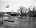
| Date: | 11 1928 |
|---|---|
| Description: | Aerial view of Stoughton, including the central business district, residential areas, the Yahara River, and the surrounding countryside. |

| Date: | 1907 |
|---|---|
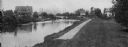
| Description: | The Yahara River Parkway, with the old Lapham School at 1436 East Dayton Street at North Thornton visible on the righthand side. |

| Date: | 1906 |
|---|---|
| Description: | View from shoreline looking over a pathway towards the Steensland Bridge and Yahara River Parkway at East Washington Avenue. |
| Date: | 02 23 1953 |
|---|---|
| Description: | University of Wisconsin crew rowing down the Yahara River. View looking south toward railroad bridge in the 100 block of North Thornton Avenue. |
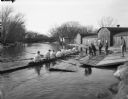
| Date: | 02 23 1953 |
|---|---|
| Description: | University of Wisconsin crew gets into their shell from the dock on the Yahara River with Trachte boat houses in the background. View looking northwest tow... |

| Date: | 07 05 1975 |
|---|---|
| Description: | The Tenney Park Bridge over the Yahara River. |
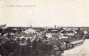
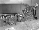
| Date: | 1907 |
|---|---|
| Description: | Elevated view of the wagon factories. Caption reads: "The Wagon Factories, Stoughton, Wis." |
If you didn't find the material you searched for, our Library Reference Staff can help.
Call our reference desk at 608-264-6535 or email us at: