 Filter: Categories of Wisconsin Historical Images
Filter: Subject of Rivers
Filter: Year of 1900-1999
Filter: Subject of transportation
Filter: Categories of Wisconsin Historical Images
Filter: Subject of Rivers
Filter: Year of 1900-1999
Filter: Subject of transportation
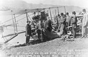
| Date: | 10 19 1911 |
|---|---|
| Description: | Pilot Hugh Robinson and his Curtiss hydroplane at Prairie du Chien during a flight that was intended to be the first all the way down the Mississippi River... |

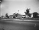
| Date: | 05 31 1965 |
|---|---|
| Description: | Elevated view of Evangelical United Brethren church in the vicinity of Highway T. |

| Date: | 1910 |
|---|---|
| Description: | Map of Dane County rural delivery in Madison and the town of Westport. |

| Date: | 1910 |
|---|---|
| Description: | Map of the general plan of the district of the Four Lakes. |

| Date: | 1923 |
|---|---|
| Description: | Map of Oneida County-Rhinelander Airport which was laid out at the county fairgrounds. The map appears on the reverse side of a letter Roy Larson received ... |
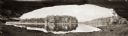
| Date: | 1900 |
|---|---|
| Description: | Panoramic view of the Wisconsin River in the Wisconsin Dells from underneath an overhanging rocky outcropping. A canoe is beached on the far left. The word... |
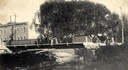
| Date: | 1904 |
|---|---|
| Description: | View across Yahara River towards a group of people on the Sherman Avenue Bridge, with the old malt house in the background. |
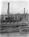
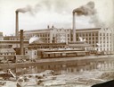
| Date: | 1911 |
|---|---|
| Description: | International Harvester's McCormick Works on the river with railroad tracks and a cargo dock. The factory was owned by the McCormick Harvesting Machine Com... |
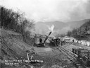
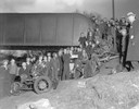
| Date: | 02 22 1919 |
|---|---|
| Description: | Workers using a steam shovel to dig a "borrow pit" for the no. 2 mine. The shovel is loading soil onto a rail car on a narrow gauge railroad track. Benham ... |
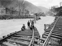
| Date: | 1919 |
|---|---|
| Description: | Men standing on the exposed portion of a flooded railroad track as a swiftly moving torrent of water is rushing past. Benham was a "company town" created b... |
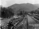
| Date: | 03 29 1919 |
|---|---|
| Description: | Men building a dock along railroad tracks. The tracks run along a stream or small river. Benham was a "company town" created by International Harvester for... |
| Date: | 1900 |
|---|---|
| Description: | Southwest panorama of the McCormick Reaper Works factory and rail yard as seen across a canal. Workers can be seen unloading wood. |

| Date: | 1913 |
|---|---|
| Description: | Bird's-eye map of Superior. "The New Steel Center." |

| Date: | 1915 |
|---|---|
| Description: | Bird's-eye view of Superior, Wisconsin, and Duluth, Minnesota on opposite shore of Lake Superior. |

| Date: | 1914 |
|---|---|
| Description: | This map shows Sheboygan in 1914. The top of the map has the date of "NOV 17 1916" stamped in red ink. The map shows numbered plots and labeled streets, an... |

| Date: | 04 18 1935 |
|---|---|
| Description: | Miss Pyre standing next to a Ford V-8 coupe near a bridge at Tenney Park. A building with a tower is in the background, perhaps the Hausmann Brewing Compan... |
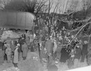
| Date: | 03 23 1934 |
|---|---|
| Description: | Crowd standing on the Thornton Avenue bank of the Yahara River at the Milwaukee Road railroad bridge looking at a car-train accident scene where Mrs. Clark... |
| Date: | 03 23 1934 |
|---|---|
| Description: | Crowd standing on the Thornton Avenue bank of the Yahara River at the Milwaukee Road railroad bridge looking at a car-train accident scene where Mrs. Clark... |
| Date: | 09 19 1928 |
|---|---|
| Description: | Marling Lumber Company, 1801 East Washington Avenue. The Yahara River is to the right, with a bridge in the background. |

| Date: | 1927 |
|---|---|
| Description: | Color map, hand-drawn with comic figures engaged in various activities throughout map. Bordered by the river on the left and Lake Michigan on the right, in... |
If you didn't find the material you searched for, our Library Reference Staff can help.
Call our reference desk at 608-264-6535 or email us at: