 Filter: Categories of Wisconsin Historical Images
Filter: Subject of Rivers
Filter: Year of 1900-1999
Filter: Subject of transportation
Filter: Year of 1990-1999
Filter: Categories of Wisconsin Historical Images
Filter: Subject of Rivers
Filter: Year of 1900-1999
Filter: Subject of transportation
Filter: Year of 1990-1999
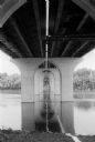
| Date: | 06 30 1992 |
|---|---|
| Description: | View from below of the Fox River Bridge. Gordon Neitzke who photographed the Fox River Bridge for the Wisconsin Department of Highways, found an almost cat... |

| Date: | 1999 |
|---|---|
| Description: | The Kishwaukee River in winter and its snow-covered banks. |

| Date: | 1994 |
|---|---|
| Description: | This brochure consists of a series of 16 maps of the Military Ridge State Park Trail and the Sugar River State Trail. In all, 62 miles of bike trails and 1... |

| Date: | 07 1991 |
|---|---|
| Description: | "Les Beck draws water from the Rock River to water eight colorful flower boxes put up by the Theresa Lions Club." |
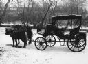
| Date: | 01 02 1993 |
|---|---|
| Description: | "Horse-drawn carriage at the corner of Mill and Henni Streets." |
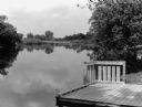
| Date: | 06 1996 |
|---|---|
| Description: | "This is the boat landing at Rivers Edge Park." |

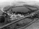
| Date: | 09 1996 |
|---|---|
| Description: | "Theresa's Bonduel & Wisconsin Streets from the air." |
| Date: | 09 1996 |
|---|---|
| Description: | "This is Theresa Station. Note the Rock River and Soo Line Railroad track." |

| Date: | 1990 |
|---|---|
| Description: | This late 20th century tourist map of Sauk County, Wisconsin, shows the highways and roads, cities and towns, parks, airports, canoe landings, hospitals, s... |

| Date: | 1991 |
|---|---|
| Description: | This 1991 map of Burnett County, Wisconsin, shows Governor Knowles State Forest, wildlife areas, public hunting grounds, and other outdoor recreation facil... |

| Date: | 01 1993 |
|---|---|
| Description: | Horses and carriage at the east end of Henni Street in winter. |

| Date: | 1992 |
|---|---|
| Description: | This guide features a map of suggested bike routes. Also included is a legend, text on how to use the map and legend, points of interest, and safety tips. |

| Date: | 1990 |
|---|---|
| Description: | This map shows the Minnesota Point, Wisconsin Point, Hog Island, Baker's Island, Connors Point, Blatnik Bridge, Superior Bay, Allouez Bay, the Nemadji Rive... |
| Date: | 1990 |
|---|---|
| Description: | This map shows Wisconsin Central Ltd. main track, lines out of service, abandoned lines, and trackage rights. The map covers Wisconsin and Michigan's upper... |

| Date: | 1994 |
|---|---|
| Description: | This map shows historical sites, picnic grounds, public boat landings, canoe and motor boat trips, and resort locations. The left margin of the map include... |

| Date: | 1990 |
|---|---|
| Description: | This map includes two insets: Plat of New Holstein village and Village of Chilton. The map also includes a table of statistics showing the assessed value o... |

| Date: | 1990 |
|---|---|
| Description: | This map, in addition to the Fort ground and buildings, shows owners of outbuildings, heights of buildings in stories, fences, roads, gardens, and cemetery... |

| Date: | 1993 |
|---|---|
| Description: | View from shoreline looking down at a light film of ice covering the surface of a river as it curves around a bend towards a bridge in the distance. A path... |

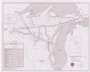
| Date: | 1997 |
|---|---|
| Description: | System map including Wisconsin Central LTD., Fox Valley and Western LTD., Algoma Central Railway, Inc., and Sault Ste. Marie Bridge Co. Detail maps at top ... |
If you didn't find the material you searched for, our Library Reference Staff can help.
Call our reference desk at 608-264-6535 or email us at: