 Filter: Categories of Wisconsin Historical Images
Filter: Subject of Rivers
Filter: Year of 1900-1999
Filter: Year of 1900-1909
Filter: Community of Madison
Filter: Categories of Wisconsin Historical Images
Filter: Subject of Rivers
Filter: Year of 1900-1999
Filter: Year of 1900-1909
Filter: Community of Madison
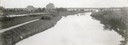
| Date: | 1908 |
|---|---|
| Description: | The Yahara River from Williamson Street with Lake Monona in the background. House & Barn pictured is located at 601 Riverside Drive. |
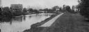
| Date: | 1908 |
|---|---|
| Description: | A view of the Yahara River below Williamson Street. |
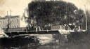
| Date: | 1904 |
|---|---|
| Description: | View across Yahara River towards a group of people on the Sherman Avenue Bridge, with the old malt house in the background. |

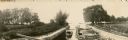
| Date: | 1907 |
|---|---|
| Description: | The Yahara River Parkway, with the old Lapham School at 1436 East Dayton Street at North Thornton visible on the righthand side. |

| Date: | 1906 |
|---|---|
| Description: | View from shoreline looking over a pathway towards the Steensland Bridge and Yahara River Parkway at East Washington Avenue. |

| Date: | 1909 |
|---|---|
| Description: | View of the lagoon at Tenney Park, surrounded by trees, with a bridge in the distance. Caption reads: "Lagoon and Bridge, Tenney Park, Madison, Wis." |

| Date: | 1905 |
|---|---|
| Description: | View of the lagoon and surrounding wooded area in Tenney Park. Caption reads: "Lagoon in Tenney Park, Madison, Wis." |

| Date: | 1907 |
|---|---|
| Description: | Bridge and Lagoon in Tenney Park. Caption reads: "Bridge and Lagoon, Tenney Park, Madison, Wisconsin." |
| Date: | 1906 |
|---|---|
| Description: | A boat full of men and women is entering the lock on the Yahara River at Tenney Park. |

| Date: | 1900 |
|---|---|
| Description: | A hydrographic map of Lake Monona and the adjacent topography. |

| Date: | 1906 |
|---|---|
| Description: | Topographical map of Turville Point and lands to the South to Nine Springs Creek. |

| Date: | 1905 |
|---|---|
| Description: | This map shows roads, railroads, and location of Keyes Springs, now part of Monona. The map reads: "L.S. Smith, c.e., del. May, 1905" and "For further info... |

| Date: | 1901 |
|---|---|
| Description: | View along the Catfish River, with shrubs and grasses covering the riverbank. On the far left are electrical poles along a dirt road bordering a field that... |
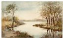
| Date: | 1906 |
|---|---|
| Description: | Watercolor painting of the Yahara River at Lake Monona. |
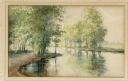
| Date: | 1906 |
|---|---|
| Description: | Watercolor painting of the Yahara River at Lake Monona, with trees in the background and wetlands in the foreground. |
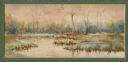
| Date: | 1906 |
|---|---|
| Description: | Watercolor painting of the Yahara River, with large trees on the shoreline. Note: '05 & '06 were the years when Tenney Park and the Yahara River Parkway ... |

| Date: | 1908 |
|---|---|
| Description: | Bird's-eye view showing Lake Mendota, Lake Monona, Lake Waubesa, Lake Wingra and Lake Kegonsa. Madison has only the isthmus developed, and there are settle... |

| Date: | 1908 |
|---|---|
| Description: | A Sanborn map of the isthmus, which includes the map key. |
If you didn't find the material you searched for, our Library Reference Staff can help.
Call our reference desk at 608-264-6535 or email us at:
