Filter: Categories of Wisconsin Historical Images
Filter: Subject of Rivers
Filter: Year of 1900-1999
Filter: Year of 1900-1909
Filter: Categories of Wisconsin Historical Images
Filter: Subject of Rivers
Filter: Year of 1900-1999
Filter: Year of 1900-1909
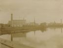
| Date: | 1907 |
|---|---|
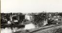
| Description: | Elevated view of the wagon factories. Caption reads: "The Wagon Factories, Stoughton, Wis." |
| Date: | 1907 |
|---|---|
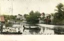
| Description: | View towards a bridge, with children in a boat in the left foreground, and two other people in a boat in the center. Caption reads: "The Old Bridge, Stough... |

| Date: | 1905 |
|---|---|
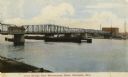
| Description: | View from shoreline toward the new Hattie Street Bridge. Factory buildings are on the shoreline behind. Caption reads: "New Hattie Street Bridge, Marinette... |
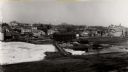
| Date: | 1908 |
|---|---|
| Description: | View from dock toward the drawbridge. Caption reads: "Drawbridge from Menekaunee Dock, Marinette, Wis." |
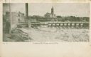
| Date: | 1905 |
|---|---|
| Description: | View from shoreline towards a river with a dam in the distance. Caption reads: "River Scene, Mayville, Wis." |
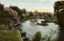
| Date: | 1900 |
|---|---|
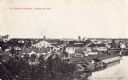
| Description: | View of Mayville behind the frozen, snow-covered river. |
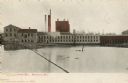
| Date: | 1905 |
|---|---|
| Description: | The Island Paper Mill and dam in Menasha. Caption reads: "Paper Mill, Menasha, Wis." |
| Date: | 1905 |
|---|---|
| Description: | The Island Paper Mill and dam in Menasha. Caption reads: "Dam & Island Paper Mill, Menasha, Wis." |
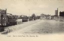
| Date: | 1905 |
|---|---|
| Description: | View across water towards a mill of the John Strange Paper Company. |

| Date: | 1908 |
|---|---|
| Description: | Elevated view of the dam on the Red Cedar River, also showing the electric power plant and mills. Caption reads: "Bridge, Falls, Electric Power House and t... |
| Date: | 1909 |
|---|---|
| Description: | The Lindaur Mill Flume. A man is standing in the left foreground. In the distance is the Court House with clocktower. Caption reads: "Lindaur Mill Flume, M... |

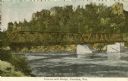
| Date: | 1905 |
|---|---|
| Description: | Horlick Park, or Island Park, showing the Kinzie Avenue bridge. |

| Date: | 1906 |
|---|---|
| Description: | View of Horlick's mill and dam, also known as "Ye Old Mill." |
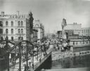
| Date: | 1900 |
|---|---|
| Description: | View looking up Wisconsin Avenue from the bridge. Many pedestrians, streetcars, and horse-drawn vehicles are visible. |

| Date: | 1900 |
|---|---|
| Description: | View across water toward the Princeton brewery on a bend in the Fox River. Caption reads: "A Bend in the Historic Fox at Princeton, Wis." |

| Date: | 1906 |
|---|---|
| Description: | Polyconic projection. Map made from surveys without spirit level control. Henry Gannett, Chief Topographer. Topography by Van H. Manning and Nat. Tyler, Jr... |
| Date: | 1905 |
|---|---|
| Description: | Petenwell Bridge. Caption reads: "Pete-eu-nell Bridge, Necedah, Wis." |

| Date: | 1908 |
|---|---|
| Description: | Colored map in perspective indicates railroad routes. Lake Winnebago and Oshkosh in center, area extends to Shawano (top right corner), Green Bay (bottom r... |

| Date: | 1905 |
|---|---|
| Description: | A day passenger train crossing the high North Western railroad bridge over the Chippewa River. Railroad tracks are along the shoreline in the foreground. |
If you didn't find the material you searched for, our Library Reference Staff can help.
Call our reference desk at 608-264-6535 or email us at: