Filter: Categories of Wisconsin Historical Images
Filter: Subject of Rivers
Filter: Year of 1900-1999
Filter: Year of 1910-1919
Filter: Year of 1919
Filter: Categories of Wisconsin Historical Images
Filter: Subject of Rivers
Filter: Year of 1900-1999
Filter: Year of 1910-1919
Filter: Year of 1919
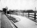
| Date: | 1919 |
|---|---|
| Description: | Deering Works factory seen across the waterfront from Diversey Avenue. In the foreground is a street and sidewalk with the sign "horse vehicles keep to rig... |
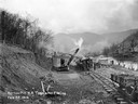
| Date: | 02 22 1919 |
|---|---|
| Description: | Workers using a steam shovel to dig a "borrow pit" for the no. 2 mine. The shovel is loading soil onto a rail car on a narrow gauge railroad track. Benham ... |
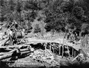
| Date: | 05 03 1919 |
|---|---|
| Description: | Workers building a culvert over Maggard's Branch near mine no. 2. Benham was a "company town" created by International Harvester for the workers employed i... |
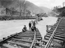
| Date: | 1919 |
|---|---|
| Description: | Men standing on the exposed portion of a flooded railroad track as a swiftly moving torrent of water is rushing past. Benham was a "company town" created b... |
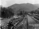
| Date: | 03 29 1919 |
|---|---|
| Description: | Men building a dock along railroad tracks. The tracks run along a stream or small river. Benham was a "company town" created by International Harvester for... |
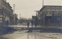
| Date: | 03 16 1919 |
|---|---|
| Description: | View showing the flood conditions on city streets from the 1919 Flood on the Trempealeau River. Four men are surveying the damage. Caption reads: "Highwate... |

| Date: | 08 08 1919 |
|---|---|
| Description: | Elevated view up the Milwaukee River from Wisconsin Avenue bridge. A World War I submarine travels down the Milwaukee River. A crowd is gathered at the riv... |

| Date: | 1919 |
|---|---|
| Description: | This is a collection of three hand-colored plat maps. One map is a plat plan and includes annotations and an index that shows public land, business, indust... |

| Date: | 1919 |
|---|---|
| Description: | Elevated view of the Rock River, with a large smokestack and water tower on the left. Richard Lloyd Jones was born in Janesville in 1873 and lived there u... |

| Date: | 1919 |
|---|---|
| Description: | This map depicts the route of the 1842 overland trip by wagon made by the Reverend Alfred Brunson and some copper miners from Prairie du Chien to the mouth... |
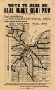
| Date: | 1919 |
|---|---|
| Description: | This flier, likely printed in 1919, promotes the vote for a bond issue to fund "hard roads" in Brown County, Wisconsin. The map shows the 135 miles of conc... |

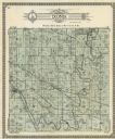
| Date: | 1919 |
|---|---|
| Description: | Colorized postcard of an elevated view of a concrete bridge over a river. There is a boat near wooden pilings that stretch from the shoreline to the center... |

| Date: | 1919 |
|---|---|
| Description: | Dr. Joseph Smith and his wife, Mary, pose next to trees by a rivers edge. |

| Date: | 1919 |
|---|---|
| Description: | Dr. Joseph Smith poses with friends next to a tree along a rivers edge. |
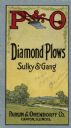
| Date: | 1919 |
|---|---|
| Description: | Brochure cover of Diamond Plows, Sulky & Gang, featuring an illustration of a landscape. |

| Date: | 1919 |
|---|---|
| Description: | This map shows details of the harbor, proposed route and bridge changes, railroads, streets, selected buildings, a portion of Lake Superior and other lakes... |

| Date: | 1919 |
|---|---|
| Description: | Narrow red lines show principal secondary highways. Green circles shows points of historical interest. Green triangles show Indian mounds and Indian villag... |

| Date: | 1919 |
|---|---|
| Description: | This map shows auto trails, main roads, rivers, and populations of communities. The map also shows selected hotels and garages and includes a key in the ri... |

| Date: | 09 01 1919 |
|---|---|
| Description: | Photographic postcard view of a river, with part of an outbuilding in the foreground on the left. On the opposite shoreline is a farm, with farmhouse, barn... |
If you didn't find the material you searched for, our Library Reference Staff can help.
Call our reference desk at 608-264-6535 or email us at: