 Filter: Categories of Wisconsin Historical Images
Filter: Subject of Rivers
Filter: Year of 1900-1999
Filter: Year of 1920-1929
Filter: County of Sheboygan
Filter: Categories of Wisconsin Historical Images
Filter: Subject of Rivers
Filter: Year of 1900-1999
Filter: Year of 1920-1929
Filter: County of Sheboygan
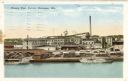
| Date: | 1925 |
|---|---|
| Description: | View across water towards the Phoenix Chair factory on the waterfront. Caption reads: "Phoenix Chair Factory, Sheboygan, Wis." |

| Date: | 1921 |
|---|---|
| Description: | This map is part of the survey of the northern and northwestern lakes. The map shows Sheboygan Harbor on the shore of Lake Michigan and the Sheboygan River... |

| Date: | 1921 |
|---|---|
| Description: | This map shows Lake Michigan, the Sheboygan River, buildings, streets, churches, industrial yards, and parks. Relief is shown by hachures and depths are sh... |

| Date: | 1926 |
|---|---|
| Description: | This blueprint map shows the Sheboygan River, buildings, and roads in the vicinity of the harbor. The map has explanations including "dredging required to ... |

| Date: | 1926 |
|---|---|
| Description: | This map includes a legend in the lower right corner of building heights. Districts marked "A" are 35 foot, districts marked "B" are 45 foot, districts mar... |

| Date: | 1926 |
|---|---|
| Description: | This map includes a legend in the lower right corner of land use. Districts are shown in five different shading for: "A" residential, "B" are residential, ... |
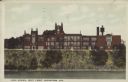
| Date: | 09 08 1923 |
|---|---|
| Description: | Text on front reads: "High School, West Front, Sheboygan, Wis." The school was named Sheboygan High School from 1922-1938, then Sheboygan Central High Scho... |

| Date: | 1922 |
|---|---|
| Description: | Text on front reads: "Aerial View of Sheboygan, Wis." The image shows the Sheboygan River from Lake Michigan to the Pennsylvania Avenue bridge. |
If you didn't find the material you searched for, our Library Reference Staff can help.
Call our reference desk at 608-264-6535 or email us at: