 Filter: Categories of Wisconsin Historical Images
Filter: Subject of Rivers
Filter: Year of 1900-1999
Filter: Year of 1920-1929
Filter: Categories of Wisconsin Historical Images
Filter: Subject of Rivers
Filter: Year of 1900-1999
Filter: Year of 1920-1929

| Date: | 1927 |
|---|---|
| Description: | Street railway and motor bus map with a legend of "Street Car Line," "Auxiliary Bus Lines," and "Motor Bus Lines." The routes are numbered. The map reads: ... |

| Date: | 1926 |
|---|---|
| Description: | Relief shown by hachures. Shows local streets, roads, railroads, businesses, Half Moon Lake, Chippewa River, and log reservoir. |

| Date: | 1925 |
|---|---|
| Description: | Map produced by the Paul E. Stark Company to advertising sales and services. Bottom of the map features sales records for 1919 to 1925 and a paragraph read... |

| Date: | 1925 |
|---|---|
| Description: | Map produced by the Paul E. Stark Company to advertising sales and services. Bottom of the map features sales records for 1919 to 1925 and a paragraph read... |

| Date: | 1927 |
|---|---|
| Description: | Shows campus buildings, points of interest in surrounding area, and railroads. Advertisements on verso. |

| Date: | 1928 |
|---|---|
| Description: | Illustrated map of points of interest, including University buildings, parks, athletic venues, fraternity and sorority houses, and state buildings. |

| Date: | 1929 |
|---|---|
| Description: | This map is oriented with north to the upper right. Includes index of retailers and buildings, with some advertisements in margins. |
| Date: | 1921 |
|---|---|
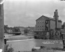
| Description: | View from shoreline over the Baraboo River towards a dam, with a mill on the opposite shoreline. A bridge and a business district are in the background. |

| Date: | 1920 |
|---|---|
| Description: | Shows lot and block numbers. Includes manuscript annotations showing original Wisconsin Central Railway line in red which reads: "Original W.C. Line in Men... |

| Date: | 1926 |
|---|---|
| Description: | View from hill looking down at homes and businesses in town. A bridge goes over the Kickapoo River. The depot and railroad tracks and Main Street are behin... |

| Date: | 1920 |
|---|---|
| Description: | Shows ward boundaries, corporation limits, plat of town, land ownership by name, local streets, parks, railroads, and parts of Rock River. Wards appear in ... |

| Date: | 1929 |
|---|---|
| Description: | View looking down at the dam on the Kickapoo River. Houses are on the far side of the river, and chimneys are blowing heavy smoke. In the far background is... |
| Date: | 1922 |
|---|---|
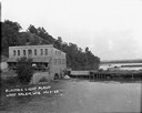
| Description: | Elevated view across water of a stone building next to an earthen dam on the La Crosse River. There is an archway on the side of the building at the river ... |

| Date: | 1921 |
|---|---|
| Description: | Map reads: "1918. Revised 1921." Key to the map in upper right hand corner reads: "Residential Districts," "Local Businesses," "Commercial and Light Manufa... |
| Date: | 1921 |
|---|---|
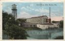
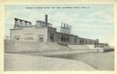
| Description: | Colorized postcard view of the exterior of the woolen mill along the banks of a river. A water tower is on the left, and a smokestack is on the right. Capt... |

| Date: | 1921 |
|---|---|
| Description: | This map is part of the survey of the northern and northwestern lakes. The map shows Sheboygan Harbor on the shore of Lake Michigan and the Sheboygan River... |
| Date: | 1920 |
|---|---|
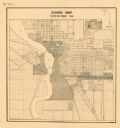
| Description: | This map shows zoning in the city of Stevens Point. Streets are labeled and the upper right hand corner features a "Legend & Summary Of Zoning Regulations"... |

| Date: | 1922 |
|---|---|
| Description: | Semi-panoramic view of rapids, water pouring near the dam of the Great Northern Paper Company. |

| Date: | 1929 |
|---|---|
| Description: | Ho-Chunk women perform the Swan Dance. There is a group of men sitting in a circle next to them. |
| Date: | 1920 |
|---|---|
| Description: | Colorized postcard view of Wissota hydroelectric power house and dam as seen from Lake Wissota upstream side. Wissota dam is east of Chippewa Falls. Captio... |
If you didn't find the material you searched for, our Library Reference Staff can help.
Call our reference desk at 608-264-6535 or email us at: