 Filter: Categories of Wisconsin Historical Images
Filter: Subject of Rivers
Filter: Year of 1900-1999
Filter: Year of 1930-1939
Filter: Categories of Wisconsin Historical Images
Filter: Subject of Rivers
Filter: Year of 1900-1999
Filter: Year of 1930-1939

| Date: | 1933 |
|---|---|
| Description: | Blue line copy on paper with manuscript additions in color. Shows boundaries of zoned areas, Wisconsin historical lands in zoned areas, county lands outsid... |
| Date: | 1930 |
|---|---|
| Description: | Shows points of historic interest in Dane County; includes explanation of historical points of interest and corresponding symbols. "Map of historic sites i... |

| Date: | 1930 |
|---|---|
| Description: | Shows county system of roads which are surfaced, well graded, common, or unimproved, town roads, state trunk highways, town and village boundaries, schools... |

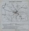
| Date: | 1930 |
|---|---|
| Description: | Shows county system of roads which are surfaced, well graded, common, or unimproved, town roads, state trunk highways, town and village boundaries, schools... |

| Date: | 1937 |
|---|---|
| Description: | "Prepared ... March 1937." Includes location map. "State of Wisconsin, Conservation Department, Map Division"--upper left. From the E.P. Sherry papers rela... |

| Date: | 1935 |
|---|---|
| Description: | Map of Juneau County showing area zoned for reforestation shaded in red. |
| Date: | 1939 |
|---|---|
| Description: | Shows location of deer, partridge, quail, prairie chicken, and pheasants. Includes game count table and significant manuscript annotations. Dated "3-25-39.... |

| Date: | 1931 |
|---|---|
| Description: | This map is an advertisement for Milwaukee street cars and motor buses and reads: "Ride the street car or motor bus. Economical, safe, dependable." Include... |

| Date: | 1930 |
|---|---|
| Description: | Lower left hand corner reads: "Compliment of the Madison Association of Commerce MADISON The Four Lake City WISCONSIN." Around the perimeter of the map is ... |
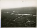
| Date: | 01 1934 |
|---|---|
| Description: | Aerial view of a forest with a river running through it. |
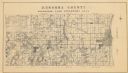
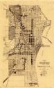
| Date: | 1934 |
|---|---|
| Description: | A land inventory map of Kenosha County. The top left features a legend of "Land Cover" and "Roads and Other Improvements". Lake Michigan is labelled to the... |

| Date: | 1938 |
|---|---|
| Description: | Color coded map in pink, yellow, blue, and brown of Milwaukee County State and County trunk highways. The map includes a legend of symbols: "STEAM RAIL ROA... |

| Date: | 1931 |
|---|---|
| Description: | Relief shown by contours and spot heights. Maps shows United States, state, county and local highways and roads, schools, North Bend, creeks, lakes, rivers... |

| Date: | 1938 |
|---|---|
| Description: | The map includes text, illustrations, a railroad fare table (season 1938), a Directory of resorts and hotels, and a regional map on the back. |

| Date: | 1931 |
|---|---|
| Description: | Map shows street map with wards numbered, the Fox River, railroads, playgrounds, cemeteries, and schools. The map also includes a manuscript annotation ind... |
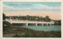
| Date: | 1938 |
|---|---|
| Description: | Colorized postcard view from shoreline of a stone bridge lined with lampposts. Dwellings and commercial buildings are on the far side. An elevated railroad... |
| Date: | 1933 |
|---|---|
| Description: | An unidentified man canoes the rapids on the Flambeau River in the northern part of Rusk County, about 12 miles from Ladysmith. |
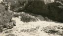
| Date: | 1931 |
|---|---|
| Description: | A group of people stand on a ledge overlooking Copper Falls. |

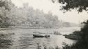
| Date: | 1935 |
|---|---|
| Description: | Two men in a canoe on the Namekagon River in northwestern Wisconsin. |
| Date: | 1935 |
|---|---|
| Description: | This map created by the Sheboygan City Engineer department shows five different types of land use in the city in 1935. A legend in the bottom right corner ... |
If you didn't find the material you searched for, our Library Reference Staff can help.
Call our reference desk at 608-264-6535 or email us at: