 Filter: Categories of Wisconsin Historical Images
Filter: Subject of Rivers
Filter: Year of 1900-1999
Filter: Year of 1930-1939
Filter: Categories of Wisconsin Historical Images
Filter: Subject of Rivers
Filter: Year of 1900-1999
Filter: Year of 1930-1939

| Date: | 1935 |
|---|---|
| Description: | This topographical map of the forest preserve shows highways, roads, trails, telephone lines, Native American reservations, Ranger sub-stations, state nurs... |

| Date: | 1939 |
|---|---|
| Description: | This illustrated map shows counties, highways, rivers, roads, present and proposed state parks and forests, proposed state parkways, proposed state monumen... |

| Date: | 1935 |
|---|---|
| Description: | This map shows railroads, telephone lines, roads, trails, schools, sub-agency, lookout stations, churches, community centers, and school site and farm. Bil... |

| Date: | 1930 |
|---|---|
| Description: | This map shows the state trunk highway system and county trunk highways. This map show surface type on state and county trunk highways and the locations of... |

| Date: | 1931 |
|---|---|
| Description: | This map shows the state trunk highway system and county trunk highways. This map show surface type on state and county trunk highways and the locations of... |

| Date: | 1933 |
|---|---|
| Description: | This map shows the state trunk highway system and county trunk highways. This map show surface type on state and county trunk highways and the locations of... |

| Date: | 1934 |
|---|---|
| Description: | This map shows the state trunk highway system and county trunk highways. This map show surface type on state and county trunk highways and the locations of... |

| Date: | 1935 |
|---|---|
| Description: | This map shows the state trunk highway system and county trunk highways. This map show surface type on state and county trunk highways and the locations of... |

| Date: | 1936 |
|---|---|
| Description: | This map shows the state trunk highway system and county trunk highways. This map show surface type on state and county trunk highways and the locations of... |

| Date: | 1938 |
|---|---|
| Description: | This map shows the state trunk highway system and county trunk highways. This map show surface type on state and county trunk highways and the locations of... |

| Date: | 1939 |
|---|---|
| Description: | This map shows the state trunk highway system and county trunk highways. This map show surface type on state and county trunk highways and the locations of... |

| Date: | 1936 |
|---|---|
| Description: | Color coded map in pink, yellow, blue, and brown of Milwaukee County State and County trunk highways. The map includes a legend of symbols: "STEAM RAIL ROA... |

| Date: | 1937 |
|---|---|
| Description: | Color coded map in pink, yellow, blue, and brown of Milwaukee County State and County trunk highways. The map includes a legend of symbols: "STEAM RAIL ROA... |
| Date: | 1930 |
|---|---|
| Description: | This cadastral map shows ownership and acreage of lots. Streets, the Kewaunee River, and Lake Michigan are labeled. |

| Date: | 1937 |
|---|---|
| Description: | This is map 1 from a set of 4 taken from an atlas. The map shows streets, neighborhoods and proposed subdivision. Lake Michigan, Algoma Outer Harbor, the A... |

| Date: | 1937 |
|---|---|
| Description: | This is map 3 from a set of 4 taken from an atlas. The map shows streets, neighborhoods, lots, and railroad tracks. Lake Michigan, the Kewaunee River, and ... |

| Date: | 1937 |
|---|---|
| Description: | This is map 4 from a set of 4 taken from an atlas. The map includes a legend in the lower left corner of roads, trails, county lines, town lines, section l... |

| Date: | 1937 |
|---|---|
| Description: | Pictorial map showing historical events and locations within the state of Wisconsin, as well as waterways and counties. Original caption on the bottom marg... |

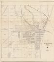
| Date: | 03 25 1931 |
|---|---|
| Description: | This blueline print map shows lot and block numbers, additions, churches, and public land in North and South wards as they were in 1884. Towards the top of... |

| Date: | 1938 |
|---|---|
| Description: | This map shows roads, parks, golf courses, airports, beaches, docks and harbors, lighthouses, and buoys within Winnebago County and parts of Waushara, Calu... |
If you didn't find the material you searched for, our Library Reference Staff can help.
Call our reference desk at 608-264-6535 or email us at: