Filter: Categories of Wisconsin Historical Images
Filter: Subject of Rivers
Filter: Year of 1900-1999
Filter: Year of 1930-1939
Filter: Categories of Wisconsin Historical Images
Filter: Subject of Rivers
Filter: Year of 1900-1999
Filter: Year of 1930-1939

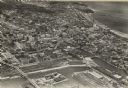
| Date: | 1935 |
|---|---|
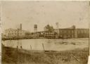
| Description: | An aerial view of numerous Manitowoc factories/industries. |
| Date: | 1930 |
|---|---|
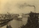
| Description: | Elevated view of the shipyards with the Badger State cement plant in background. |
| Date: | 10 28 1938 |
|---|---|
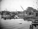
| Description: | Docks and shanties at Jones Island, with smokestacks and cranes in the background. |
| Date: | 10 1939 |
|---|---|
| Description: | View from shoreline towards the opposite shoreline of the Wolf River Paper Company factory complex on the Wolf River. |
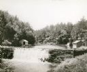
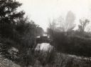
| Date: | 1930 |
|---|---|
| Description: | View of the mill dam on Dell Creek that creates Mirror Lake in Mirror Lake State Park (although the photograph was taken before the site was designated as ... |

| Date: | 1939 |
|---|---|
| Description: | A color, pictorial map. Scale: 10 miles to the inch. Shows state parks and forests, proposed state parkways, proposed state monuments and memorials, nation... |
| Date: | 1935 |
|---|---|
| Description: | Elevated view of the Indian Agency House near the site of Fort Winnebago. View of Portage Canal in foreground. The canal was dug in 1849 as part of the Fox... |
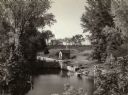
| Date: | 1935 |
|---|---|
| Description: | A view of the Portage Canal and lock. The Indian Agency House in the center background. The canal was dug in 1849 as part of the Fox-Wisconsin waterway pro... |
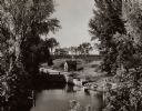
| Date: | 1935 |
|---|---|
| Description: | A view of the Portage Canal. In the immediate foreground is the Fox River, then the lower locks and the canal itself. The Indian Agency House may be seen t... |
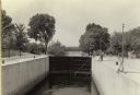
| Date: | 1935 |
|---|---|
| Description: | A view of the canal locks of the Portage Canal. Men are standing at the edge of the locks on the right. |

| Date: | 1930 |
|---|---|
| Description: | Aerial view looking east at Mt. Trempealeau from Brady's Bluff in Perrot State Park. The Mississippi River is visible along the bluffs at upper left, and t... |
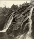
| Date: | 1938 |
|---|---|
| Description: | Little Manitou Falls on the Black River. Referred to as the "upper falls" in the park. A person is sitting on the rocks on top of the falls. This waterfall... |

| Date: | 1937 |
|---|---|
| Description: | Lighthouse built by State Senator William Bray of Oshkosh, on a point where the Fox River empties into Lake Winnebago. |
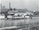
| Date: | 02 28 1935 |
|---|---|
| Description: | An Island Waterways Corporation boat docks by the North Pier River Barge Terminal near the McCormick Works (factory). |

| Date: | 1939 |
|---|---|
| Description: | Several men pass through the locks at the Lake Mendota entrance to the Yahara River. |
| Date: | 1938 |
|---|---|
| Description: | Aerial view of rivers, with Lake Michigan in upper right, train yards, and highway in lower left. |
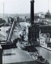
| Date: | 1938 |
|---|---|
| Description: | Elevated view of a tugboat pulling a lake steamer on the Milwaukee River under an open drawbridge near the Electric Company. |
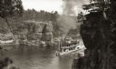
| Date: | 1931 |
|---|---|
| Description: | Second to last steamboat on the river taken before 1931, burned in 1931. Taken from Romance Cliff, "The Apollo" is shown coming through with smoke billowin... |
If you didn't find the material you searched for, our Library Reference Staff can help.
Call our reference desk at 608-264-6535 or email us at: