 Filter: Categories of Wisconsin Historical Images
Filter: Subject of Rivers
Filter: Year of 1900-1999
Filter: Year of 1930-1939
Filter: Year of 1939
Filter: Categories of Wisconsin Historical Images
Filter: Subject of Rivers
Filter: Year of 1900-1999
Filter: Year of 1930-1939
Filter: Year of 1939
| Date: | 10 1939 |
|---|---|
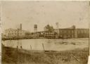
| Description: | View from shoreline towards the opposite shoreline of the Wolf River Paper Company factory complex on the Wolf River. |

| Date: | 1939 |
|---|---|
| Description: | A color, pictorial map. Scale: 10 miles to the inch. Shows state parks and forests, proposed state parkways, proposed state monuments and memorials, nation... |

| Date: | 1939 |
|---|---|
| Description: | Several men pass through the locks at the Lake Mendota entrance to the Yahara River. |
| Date: | 1939 |
|---|---|
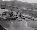
| Description: | Elevated view of group of boats and people on shoreline of a river in Peru, with mountains in the background. |

| Date: | 05 1939 |
|---|---|
| Description: | International TD-35 Diesel TracTracTor (crawler tractor) owned by A.C. Duval. A man uses the machine to push logs into the Spanish River. The river is loc... |
| Date: | 06 1939 |
|---|---|
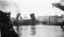
| Description: | Bridge on the Manitowoc River raised to allow the Pere Marquette car ferry through. River dredging equipment can be seen in the foreground. |

| Date: | 06 26 1939 |
|---|---|
| Description: | Colorized postcard view from hill toward the bridge along the right crossing the river. The bridge was completed in 1924. Caption reads: "Soldiers' and Sai... |

| Date: | 1939 |
|---|---|
| Description: | This map shows the towns to Gingles, Sanborn, and Guney as well as Chequamegon Bay, Kakagon River, White River, Marengo River, Bad River, Potato River, Vau... |

| Date: | 1939 |
|---|---|
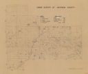
| Description: | This map of Sauk County, Wisconsin, shows the township and range grid, towns, sections, cities and villages, roads, railroads, lakes and rivers, schools, a... |

| Date: | 1939 |
|---|---|
| Description: | This map of Walworth County, Wisconsin, shows the lakes and streams flowing into the Fox River and the lakes and streams flowing into the Rock River. The d... |
| Date: | 1939 |
|---|---|
| Description: | Shows location of deer, partridge, quail, prairie chicken, and pheasants. Includes game count table and significant manuscript annotations. Dated "3-25-39.... |

| Date: | 1939 |
|---|---|
| Description: | This is a zoning map of Wauwatosa with a key of districts including agricultural, resident, business, commercial, and industrial. The map features labeled ... |

| Date: | 1939 |
|---|---|
| Description: | This illustrated map shows counties, highways, rivers, roads, present and proposed state parks and forests, proposed state parkways, proposed state monumen... |

| Date: | 1939 |
|---|---|
| Description: | This map shows the state trunk highway system and county trunk highways. This map show surface type on state and county trunk highways and the locations of... |

| Date: | 02 09 1939 |
|---|---|
| Description: | Elevated, panoramic view from upstream towards the Guntersville Dam. |

| Date: | 02 09 1939 |
|---|---|
| Description: | Aerial, panoramic view from downstream towards the Chickamauga Dam. |

| Date: | 02 09 1939 |
|---|---|
| Description: | Elevated, panoramic view from downstream shoreline towards the Guntersville Dam. |
If you didn't find the material you searched for, our Library Reference Staff can help.
Call our reference desk at 608-264-6535 or email us at:
