 Filter: Categories of Wisconsin Historical Images
Filter: Subject of Rivers
Filter: Year of 1900-1999
Filter: Year of 1940-1949
Filter: Categories of Wisconsin Historical Images
Filter: Subject of Rivers
Filter: Year of 1900-1999
Filter: Year of 1940-1949

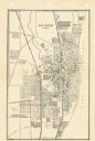
| Date: | 1947 |
|---|---|
| Description: | This map of Wauwatosa shows 10 zoning class types of land including residential, manufacturing, and business. The map also shows government buildings, some... |

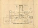
| Date: | 1940 |
|---|---|
| Description: | This map of Aztalan is pencil and ink on paper. The map shows streets, local businesses, churches, houses, and the Crawfish River. The map reads: "Informat... |

| Date: | 1940 |
|---|---|
| Description: | This map of Beaver Dam pictorially shows the history of the town. The map was made for the 100th anniversary celebration of Beaver Dam in 1941. The map inc... |

| Date: | 1942 |
|---|---|
| Description: | This map of Burlington shows plat of the town, city limits, section lines, 1/4 section lines of the plat sections, roads, railroads, rivers, and lakes. The... |
| Date: | 1947 |
|---|---|
| Description: | This map of Racine has labeled streets, the Root River, Lake Michigan, and includes manuscript annotations of newly annexed areas and African-American neig... |
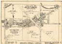
| Date: | 1943 |
|---|---|
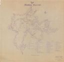
| Description: | This map of the Village of Gleason shows land ownership by name, local streets, railroads, churches, schools, and part of Prairie River. The bottom left of... |

| Date: | 1940 |
|---|---|
| Description: | This ward map shows streets, the Nemadji River, and addition and division boundaries. Also included is a list of members of the Douglas County Board town, ... |

| Date: | 1940 |
|---|---|
| Description: | A colored photographic elevated view of Irvine Park. There are park roads, a bridge and trees. Caption reads: "Chippewa Falls, Wis. General View, Irvine Pa... |
| Date: | 1949 |
|---|---|
| Description: | This map is ink and pencil on paper and shows land ownership by name, years of purchase, and city limits. Also included on the right and bottom margins are... |

| Date: | 1945 |
|---|---|
| Description: | This maps shows roads, railroads, parks, recreational areas, Lake Wingra, Lake Monona, and part of Lake Mendota. The map includes pictorial images that dep... |

| Date: | 1948 |
|---|---|
| Description: | This blue line print map shows lot and block numbers and dimensions, buildings, streets, railroads, and the Wolf River. |

| Date: | 1948 |
|---|---|
| Description: | This map is ink on tracing paper and shows acreages, wards, streets, rivers, and Lake Michigan. Also included are editorial notes in pencil. |

| Date: | 1941 |
|---|---|
| Description: | This is map one of three maps that show trails, roads and fire lanes, utilities, resorts, submerged lakes, vegetation, flowage right lands, and timber righ... |

| Date: | 1947 |
|---|---|
| Description: | This map shows lakes, rivers, railroads, and the soil types of Langlade County. Legends of soil types, conventional signs, and stoniness and slope are incl... |

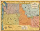
| Date: | 1949 |
|---|---|
| Description: | This pictorial map shows the United States west of the Mississippi, including Indian Tribes, historic trails, forts, trading posts, mountain ranges, lakes ... |

| Date: | 1948 |
|---|---|
| Description: | This illustrated map shows major westward trails from 1785 to 1866: Old Oregon Trail and its deviations, Old Spanish Trail, Lewis and Clark route, Santa Fe... |
| Date: | 1948 |
|---|---|
| Description: | This map shows routes of the Old Oregon, Lewis and Clark, Barlow Road, Applegate, Fremont, and Haches Pass trails. Rivers, lakes, and mountains are labeled... |
| Date: | 1941 |
|---|---|
| Description: | This is map two of a set of three and shows boundaries and flowage right lands in red ink. A legend in the lower right corner includes a legend of symbols ... |

| Date: | 1941 |
|---|---|
| Description: | This is map three of a set of three, and shows trails, roads and fire lanes, utilities, resorts, submerged lakes, vegetation, flowage right lands, and timb... |

| Date: | 1942 |
|---|---|
| Description: | This map shows the route of the Milwaukee Road, roads, foot trails, resorts, and ranger stations. The map includes text, illustrations, a railroad fare tab... |
If you didn't find the material you searched for, our Library Reference Staff can help.
Call our reference desk at 608-264-6535 or email us at: