Filter: Categories of Wisconsin Historical Images
Filter: Subject of Rivers
Filter: Year of 1900-1999
Filter: Year of 1940-1949
Filter: Year of 1942
Filter: Categories of Wisconsin Historical Images
Filter: Subject of Rivers
Filter: Year of 1900-1999
Filter: Year of 1940-1949
Filter: Year of 1942
| Date: | 1942 |
|---|---|
| Description: | Trees interspersed with college buildings in lower half of image, with Fox River bisecting the middle, and a few buildings across the river with open fiel... |
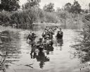
| Date: | 11 15 1942 |
|---|---|
| Description: | Members of the 32nd Division crossing a river somewhere in New Guinea behind Colonel H.A. Smith, commander of the division. The much-decorated unit was or... |

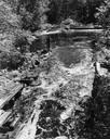
| Date: | 1942 |
|---|---|
| Description: | Warden Kramer and his assistant in a boat removing an illegal snag line from the Wolf River. |
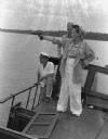
| Date: | 1942 |
|---|---|
| Description: | Olive Brooks, Army Division Engineer Public Relations with her .45 on the "Dolphin", Chucunaque River, Panama. She is pointing her gun out towards the rive... |

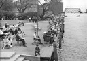
| Date: | 12 1942 |
|---|---|
| Description: | Indigenous Panamanian women and children eating dinner along the Chucunaque River. A woman in a jumpsuit holding a hat is watching Panamanian children eati... |

| Date: | 1942 |
|---|---|
| Description: | This map shows the Wisconsin and Fox River routes in green, and the Milwaukee and Rock River Canal routes in red. Prairie du Chien, Fort Winnebago, Grand C... |

| Date: | 12 25 1942 |
|---|---|
| Description: | This hand-drawn map shows the highways and features in the Rock Lake-Lake Mills area in the towns of Aztalan and Lake Mills, Jefferson County, Wisconsin. T... |

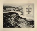
| Date: | 11 14 1942 |
|---|---|
| Description: | This pictorial map illustrates Potawatomi Indian legends from the region of Lower Phantom Lake, labeled Howitt Lake on the map, Phantom Lake, and Mukwonag... |

| Date: | 1942 |
|---|---|
| Description: | This map of Burlington shows plat of the town, city limits, section lines, 1/4 section lines of the plat sections, roads, railroads, rivers, and lakes. The... |

| Date: | 1942 |
|---|---|
| Description: | This map shows the route of the Milwaukee Road, roads, foot trails, resorts, and ranger stations. The map includes text, illustrations, a railroad fare tab... |

| Date: | 1942 |
|---|---|
| Description: | This map shows a paper city laid out in 1836 on the Wisconsin River, now the site of Wyalusing State Park, Grant County. The upper right corner includes a ... |

| Date: | 1942 |
|---|---|
| Description: | This photostat map shows roads, ferry, impassible marsh land, the Menominee River, the Milwaukee River, and Lake Michigan. |

| Date: | 1942 |
|---|---|
| Description: | Black and white aerial view of La Crosse and the Mississippi River, including Riverside Park, the Black River and La Crosse River. |
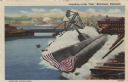
| Date: | 1942 |
|---|---|
| Description: | View of a submarine launch at the Manitowoc shipyards. Caption reads: "Launching of the "Peto", Manitowoc, Wis." |
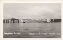
| Date: | 1942 |
|---|---|
| Description: | Text on front reads: "Arrowhead Bridge, Duluth-Superior Harbor. The bridge connected Superior, Wisconsin, with Duluth, Minnesota, over the St. Louis River.... |
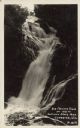
| Date: | 08 07 1942 |
|---|---|
| Description: | Text on front reads: "Big Manitou Falls, Ht. 165 Ft., Pattison State Park, Superior, Wis." The falls are on the Black River and surrounded by shrubs and ro... |
If you didn't find the material you searched for, our Library Reference Staff can help.
Call our reference desk at 608-264-6535 or email us at: