 Filter: Categories of Wisconsin Historical Images
Filter: Subject of Rivers
Filter: Year of 1900-1999
Filter: Year of 1950-1959
Filter: Creator Name of Unknown
Filter: Categories of Wisconsin Historical Images
Filter: Subject of Rivers
Filter: Year of 1900-1999
Filter: Year of 1950-1959
Filter: Creator Name of Unknown
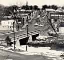
| Date: | 1959 |
|---|---|
| Description: | Elevated view of street with bridge in Darlington. Cars are parked in the center of the street at an angle. |

| Date: | 04 1959 |
|---|---|
| Description: | The Mississippi River Logging Company's railroad grade two miles south of Weyerhaeuser over Soft Maple Creek, built about 1875-76. |

| Date: | 04 1959 |
|---|---|
| Description: | The Mississippi River Logging Company's dam built in Soft Maple Creek in 1877. |

| Date: | 04 1959 |
|---|---|
| Description: | The Mississippi River Logging Company's dam built in Soft Maple Creek in 1877. |

| Date: | 1950 |
|---|---|
| Description: | State Highway 93 Bridge over the Black River under construction. |

| Date: | 1950 |
|---|---|
| Description: | Looking south. Bridge in foreground is over Kinnickinnic River. Bridge over the road holds railroad tracks. In background are several houses and a build... |
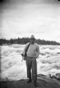
| Date: | 1955 |
|---|---|
| Description: | Sigurd Olson, wearing his characteristic attire, on a trip on the Upper Churchill River. |

| Date: | 1958 |
|---|---|
| Description: | Supreme Court Justice William O. Douglas during a canoe trip with conservationist Sigurd F. Olson. He is sitting with his hat in hand beside a canoe pulled... |
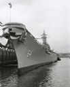
| Date: | 1957 |
|---|---|
| Description: | U.S.S. Wisconsin docked on the Hudson River at Norfolk, during decommissioning ceremonies. |

| Date: | 1956 |
|---|---|
| Description: | Includes street index. Shows local streets, parks, highways, railroads, Fond du Lac River, and part of lake Winnebago. Also includes text on points of inte... |

| Date: | 1952 |
|---|---|
| Description: | Map shows roads, highways, railroads, parks, city buildings, schools, cemeteries, city limits, and the Fox River. The map is indexed by street name, street... |

| Date: | 1951 |
|---|---|
| Description: | This map of Superior shows labeled streets, waterways, railroads, and company ownership of docks. |

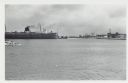
| Date: | 1950 |
|---|---|
| Description: | Aerial view showing shipyards, rivers and roads. |

| Date: | 01 08 1958 |
|---|---|
| Description: | Elevated view from 8th Street Bridge over the Manitowoc River towards Lake Michigan. There is a lighthouse in the distance. Ice is floating on the water. A... |

| Date: | 01 08 1958 |
|---|---|
| Description: | Elevated view over icy water towards ships in the shipyard on the left, and the cement company in the background. Cranes and industrial buildings are in th... |

| Date: | 01 07 1958 |
|---|---|
| Description: | View from the Second Street bridge over the icy Ahnapee River towards Lake Michigan. A lighthouse is at the end of a jetty in the far background. Boats are... |
| Date: | 01 07 1958 |
|---|---|
| Description: | View across water to ship moored at a dock. Smoke is coming out of the smokestack. Industrial buildings are across the water on the right. |

| Date: | 01 08 1958 |
|---|---|
| Description: | View of Two Rivers Harbor from shoreline towards Lake Michigan. Snow is on the ground, and a fence made of thick posts and cable is along the shoreline on ... |

| Date: | 1952 |
|---|---|
| Description: | This map shows roads, foot and canoe trails, railroads, resorts, lookout towers, camps, national and state forests, Indian reservation, and types of fish i... |

| Date: | 1955 |
|---|---|
| Description: | This map shows roads, golf courses, airports, fire towers, schools, camp grounds, rivers, streams, lakes, and railroads. The right margin of the map includ... |
If you didn't find the material you searched for, our Library Reference Staff can help.
Call our reference desk at 608-264-6535 or email us at: