 Filter: Categories of Wisconsin Historical Images
Filter: Subject of Rivers
Filter: Year of 1900-1999
Filter: Year of 1950-1959
Filter: Subject of transportation
Filter: Categories of Wisconsin Historical Images
Filter: Subject of Rivers
Filter: Year of 1900-1999
Filter: Year of 1950-1959
Filter: Subject of transportation
| Date: | 1953 |
|---|---|
| Description: | Exterior view of the Milwaukee Railroad superdome passenger car passing through the Wisconsin Dells. |

| Date: | 1955 |
|---|---|
| Description: | Artist's conception of ancient village of Aztalan, fortified with high walls surrounding it. |

| Date: | 1950 |
|---|---|
| Description: | Map showing buildings formerly used as Ringling Brothers Circus winter quarters, along with adjoining buildings. |
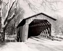
| Date: | 1957 |
|---|---|
| Description: | Covered bridge over Cedar Creek in Ozaukee County on highway, about one mile north of Cedarburg. The last remaining covered bridge in Wisconsin. Snow is on... |
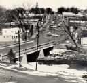
| Date: | 1959 |
|---|---|
| Description: | Elevated view of street with bridge in Darlington. Cars are parked in the center of the street at an angle. |

| Date: | 1956 |
|---|---|
| Description: | Aerial view looking northeast from a point over the east end of Middleton, showing the west end of Lake Mendota (right mid-ground). Fox Bluff juts into the... |

| Date: | 1950 |
|---|---|
| Description: | Aerial view of downtown and river. |
| Date: | 02 23 1953 |
|---|---|
| Description: | University of Wisconsin crew rowing down the Yahara River. View looking south toward railroad bridge in the 100 block of North Thornton Avenue. |
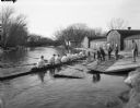
| Date: | 02 23 1953 |
|---|---|
| Description: | University of Wisconsin crew gets into their shell from the dock on the Yahara River with Trachte boat houses in the background. View looking northwest tow... |
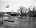
| Date: | 1953 |
|---|---|
| Description: | Nemadji River at the foot of 2nd Avenue and Robertson Avenue. A man is standing near the grassy shoreline in the center. |

| Date: | 1950 |
|---|---|
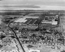
| Description: | An aerial view of town, showing a major industrial area. |

| Date: | 1950 |
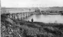
|---|---|
| Description: | State Highway 93 Bridge over the Black River under construction. |
| Date: | 1950 |
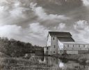
|---|---|
| Description: | Grist mill. Two people with bicycles on bridge near mill. |
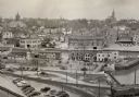
| Date: | 1952 |
|---|---|
| Description: | An elevated view of the downtown section. |

| Date: | 1952 |
|---|---|
| Description: | Riverside Park, as seen from the south side of the Fox River. A section of the Main street bridge can be seen at the left. |

| Date: | 1950 |
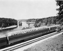
|---|---|
| Description: | Aerial view of the Highway 21 bridge and Petenwell Dam on the Wisconsin River. |
| Date: | 1954 |
|---|---|
| Description: | An aerial view of the International Harvester Memphis Works in Memphis, Tennessee, with a view of the surrounding neighborhood and Loosahatchie River. The ... |
| Date: | 1958 |
|---|---|
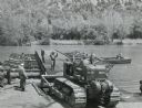
| Description: | Soldier using an International TD-18 crawler tractor (TracTracTor) during a training exercise. The original caption reads: "A graduate of the school assign... |
If you didn't find the material you searched for, our Library Reference Staff can help.
Call our reference desk at 608-264-6535 or email us at:

