 Filter: Categories of Wisconsin Historical Images
Filter: Subject of Rivers
Filter: Year of 1900-1999
Filter: Year of 1950-1959
Filter: Categories of Wisconsin Historical Images
Filter: Subject of Rivers
Filter: Year of 1900-1999
Filter: Year of 1950-1959

| Date: | 1957 |
|---|---|
| Description: | Map is indexed by street name in the margins. The map shows roads, highways, railroads, parks, city buildings, schools, cemeteries, city limits, and the Fo... |

| Date: | 08 22 1959 |
|---|---|
| Description: | Mayor Ivan Nestingen leads the parade of boats that opened the new Tenney Park lock on Saturday morning. |

| Date: | 09 1957 |
|---|---|
| Description: | Loehrke/Zastrow wedding. The Mayville Park Pavilion is reflected in the Rock River. |

| Date: | 1951 |
|---|---|
| Description: | This map of Superior shows labeled streets, waterways, railroads, and company ownership of docks. |

| Date: | 1954 |
|---|---|
| Description: | This map of Waukesha shows numbered ward boundaries, roads, and some buildings. The bottom of the map includes a street index. |

| Date: | 04 01 1958 |
|---|---|
| Description: | An antique 82-year-old horse-drawn hearse, pushed by pranksters into the Milwaukee River near the North Avenue bridge, being pulled out by a tow-truck, as ... |
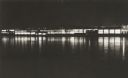
| Date: | 1957 |
|---|---|
| Description: | Long, low industrial building (factory?), probably in Green Bay, Wis., at night, from across the river, with reflections of interior lighting. |

| Date: | 1952 |
|---|---|
| Description: | This map of Beaver Dam shows state trunk highway system, county trunk highway system, town roads, rivers, and Beaver Dam Lake and includes an additional at... |
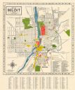
| Date: | 1952 |
|---|---|
| Description: | This colorful map of Beloit shows roads, railroads, rivers, creeks, business districts, industrial areas, and parks and recreation areas. The map includes ... |

| Date: | 1951 |
|---|---|
| Description: | This map of Chippewa Falls shows the city of Chippewa River, city limits, roads, highways, fair grounds, and parks. |

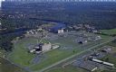
| Date: | 1950 |
|---|---|
| Description: | Aerial view showing shipyards, rivers and roads. |

| Date: | 1956 |
|---|---|
| Description: | This map of Racine includes a street directory and index of public buildings. Streets, points of interest, Lake Michigan, and the Root River are labeled. A... |

| Date: | 1950 |
|---|---|
| Description: | This map of Racine's business section is oriented with the north to the right and shows businesses and lot owners. Businesses, streets, and the Root River ... |

| Date: | 1951 |
|---|---|
| Description: | This map has depths shown by bathymetric tints and soundings and relief shown by contours, the depths are shown in feet. There is an inset map of Green Bay... |

| Date: | 08 03 1953 |
|---|---|
| Description: | Boaters passing by through the Tenney Park lock in three motor boats. |

| Date: | 1956 |
|---|---|
| Description: | This maps shows voting precincts and polling places as well as wards. Streets and the Sheboygan River are labeled. The bottom right of the map features a l... |

| Date: | 09 1950 |
|---|---|
| Description: | This map show streets, points of interest, Lake Winnebago and bays, Lake Butte Des Morts, and the Fox River. The back of the map includes a directory of t... |
| Date: | 1950 |
|---|---|
| Description: | Aerial view of Sacred Heart Hospital. |

| Date: | 1950 |
|---|---|
| Description: | Front view of George Washington's Mount Vernon from the circular driveway. A line of people are waiting at the entrance. The cupola on the roof has a weath... |

| Date: | 1950 |
|---|---|
| Description: | View across street towards several men and women standing in a park with trees and benches. Some of them are taking photographs of the United States Naval ... |
If you didn't find the material you searched for, our Library Reference Staff can help.
Call our reference desk at 608-264-6535 or email us at: