 Filter: Categories of Wisconsin Historical Images
Filter: Subject of Rivers
Filter: Year of 1900-1999
Filter: Year of 1950-1959
Filter: Categories of Wisconsin Historical Images
Filter: Subject of Rivers
Filter: Year of 1900-1999
Filter: Year of 1950-1959
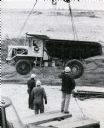
| Date: | 1958 |
|---|---|
| Description: | A riverside crew is alerted of a payhauler's descent during construction on the Glen Canyon Dam on the Colorado River. |

| Date: | 1959 |
|---|---|
| Description: | Color photo of an International truck driving beneath a bridge spanning a dam on the Colorado River. |
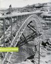
| Date: | 1959 |
|---|---|
| Description: | An International truck sits on a bridge spanning Glen Canyon and the Colorado River. |

| Date: | 1953 |
|---|---|
| Description: | A map of Lake Mendota that shows depths and the locations of various species of fish in lake. The maps also identifies a number of selected roads and stree... |

| Date: | 09 17 1959 |
|---|---|
| Description: | A map of the Menominee Indian Reservation that shows the highways, different types of roads, rivers and streams in the area. |

| Date: | 1952 |
|---|---|
| Description: | This 1952 map shows the trails, roads, and railroads through the counties of Ashland, Bayfield, Sawyer, Price, Iron, and Vilas. Also shown are lakes, river... |

| Date: | 1952 |
|---|---|
| Description: | This map of the northern parts of the Chequamegon Bay area in Bayfield and Ashland counties, Wisconsin, shows trails, roads, railroads, stations, the towns... |

| Date: | 1952 |
|---|---|
| Description: | This Wisconsin Conservation Dept. map shows sections, roads, rivers, and lakes in the Town of Cloverland, Vilas County, Wisconsin as of February, 1952. It ... |

| Date: | 1952 |
|---|---|
| Description: | This Wisconsin Conservation Dept. map shows sections, roads, rivers, and lakes in the Town of Presque Isle, Vilas County, Wisconsin as of March 1953. It do... |

| Date: | 1955 |
|---|---|
| Description: | This 1950s tourist brochure features a map of Burnett County, Wisconsin, and northern Polk County which shows highways and roads, railroads, landmarks, and... |
| Date: | 1950 |
|---|---|
| Description: | This map shows the plat of the village of Lakehurst, on the Red Cedar River in the Town of Tainter, Dunn County, Wisconsin. |

| Date: | 1953 |
|---|---|
| Description: | "Compliments of the Douglas County Highway Department"--Top margin. Shows federal highways, state trunk highways, county highways, town roads, unimproved ... |

| Date: | 1950 |
|---|---|
| Description: | This map is accompanied by booklet: "Know Milwaukee Map and Street Guide". The map is a detailed map of Milwaukee and the surrounding suburbs. Streets and ... |

| Date: | 1951 |
|---|---|
| Description: | Water depths shown by bathymetric tints, isolines, and soundings. Relief shown by contours. "Soundings in feet." "Aids to navigation corrected to May 4, 19... |

| Date: | 1951 |
|---|---|
| Description: | Water depths shown by bathymetric tints and soundings. Relief shown by contours. "Depths in feet." "Aids to navigation corrected to May 4, 1951." On verso:... |

| Date: | 1956 |
|---|---|
| Description: | Includes street index. Shows local streets, parks, highways, railroads, Fond du Lac River, and part of lake Winnebago. Also includes text on points of inte... |

| Date: | 1956 |
|---|---|
| Description: | Includes street index and index to points of interest. Shows land ownership by name, plat of town, local streets, schools, parks, highways, railroads, ward... |

| Date: | 01 08 1959 |
|---|---|
| Description: | Work on the new Tenney Park lock and dam is progressing on schedule. A temporary spillway (not shown) has been built to divert the Yahara River from the co... |

| Date: | 1952 |
|---|---|
| Description: | Map shows roads, highways, railroads, parks, city buildings, schools, cemeteries, city limits, and the Fox River. The map is indexed by street name, street... |

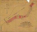
| Date: | 04 1956 |
|---|---|
| Description: | Map includes an index for building locations on the Lawrence University campus in the upper right hand corner. Map shows roads, rivers, campus buildings by... |
If you didn't find the material you searched for, our Library Reference Staff can help.
Call our reference desk at 608-264-6535 or email us at: