 Filter: Categories of Wisconsin Historical Images
Filter: Subject of Rivers
Filter: Year of 1900-1999
Filter: Year of 1960-1969
Filter: County of Brown
Filter: Categories of Wisconsin Historical Images
Filter: Subject of Rivers
Filter: Year of 1900-1999
Filter: Year of 1960-1969
Filter: County of Brown
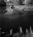
| Date: | 1963 |
|---|---|
| Description: | View from shoreline of a boat on Suamico River. |
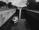
| Date: | 08 04 1962 |
|---|---|
| Description: | A boat in the Fox River Canal, headed up river. This particular lock, the Ripide Croche Lock, is located just north of Wrightstown. |
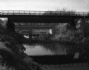
| Date: | 10 13 1963 |
|---|---|
| Description: | View from river bank of a railroad and a highway bridge crossing the Suamico River. |
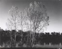
| Date: | 10 12 1963 |
|---|---|
| Description: | View from shoreline through trees towards houses on the opposite shoreline along the Fox River. |

| Date: | 1961 |
|---|---|
| Description: | This map shows established harbor lines, local streets, railroads, U.S. government channel, and part of Fox River. The map includes a table of reference po... |
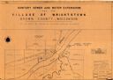
| Date: | 1961 |
|---|---|
| Description: | This map shows a sewage treatment plant site and includes an index of "Title and Index," "Watermain Details," "Sanitary Sewer Details," and "Plan B Profile... |

| Date: | 1965 |
|---|---|
| Description: | This map shows landownership, acreages, and roads. The city of De Pere, the town of Hobart, and the Fox River are labeled. Inset maps showing Smits Subdivi... |

| Date: | 1960 |
|---|---|
| Description: | This map is a facsimile of a 1829 map and shows private land claims, landowners within military reserve boundaries, sawmill, Fort Howard, public barns, bri... |
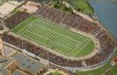
| Date: | 1965 |
|---|---|
| Description: | Overhead view of the football stadium before it was renamed Lambeau. The stadium is full of spectators and a game is in progress. |
If you didn't find the material you searched for, our Library Reference Staff can help.
Call our reference desk at 608-264-6535 or email us at: