 Filter: Categories of Wisconsin Historical Images
Filter: Subject of Rivers
Filter: Year of 1900-1999
Filter: Year of 1960-1969
Filter: County of Milwaukee
Filter: Categories of Wisconsin Historical Images
Filter: Subject of Rivers
Filter: Year of 1900-1999
Filter: Year of 1960-1969
Filter: County of Milwaukee

| Date: | 1961 |
|---|---|
| Description: | View of building under construction from a boat on the river. |

| Date: | 1965 |
|---|---|
| Description: | A map of Milwaukee County showing the county supervisor districts and the city wards. The map also includes the names of those on the on the board of elect... |

| Date: | 1960 |
|---|---|
| Description: | Color coded map in pink, yellow, blue, and brown of Milwaukee County State and County trunk highways. The map includes a legend of symbols: "STEAM RAIL ROA... |

| Date: | 1964 |
|---|---|
| Description: | This map is a hand-colored blue line print and shows 4 residence zones, 2 business zones, 1 light manufacturing zones, schools, and parks. The zones are ou... |

| Date: | 1960 |
|---|---|
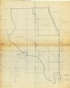
| Description: | This blue print map shows village limits, collector residential streets, and primary residential streets. The upper right corner features a key to street t... |

| Date: | 1965 |
|---|---|
| Description: | This map shows wards, city limits, railroad right of way, proposed future streets, and approximate street elevations. Wards and public schools are labeled ... |
| Date: | 02 25 1965 |
|---|---|
| Description: | This blue line print map shows annexed land with ordinance numbers and dates. |

| Date: | 1965 |
|---|---|
| Description: | This map shows 32 zoning districts, house numbering system, parks, cemeteries, and Milwaukee County institutional buildings. |

| Date: | 1966 |
|---|---|
| Description: | This map shows city, suburban, parochial and other types schools, with an explanation of symbols in the right margin. The original caption for the map read... |
| Date: | 1967 |
|---|---|
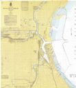
| Description: | This map shows the harbor, streets, and some buildings. Also includes the Menomonee River, the Kinnickinnic River, the Municipal mooring Basin, and Lake Mi... |
| Date: | 1962 |
|---|---|
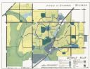
| Description: | This map shows zoning, community facilities, roads, rivers and thoroughfares. The lower right corner includes a key titled "General Plan". |

| Date: | 1965 |
|---|---|
| Description: | This series of 17 maps show boundaries and changes in city limits from 1846 to 1965. The base of all of the maps are the same, Milwaukee and suburbs. All m... |
| Date: | 1968 |
|---|---|
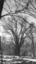
| Description: | A towering specimen of Ulmus americana standing along the river in the Menomonee River Parkway. There are large blocks of ice on the shore. This tre... |
If you didn't find the material you searched for, our Library Reference Staff can help.
Call our reference desk at 608-264-6535 or email us at: