 Filter: Categories of Wisconsin Historical Images
Filter: Subject of Rivers
Filter: Year of 1900-1999
Filter: Year of 1960-1969
Filter: Categories of Wisconsin Historical Images
Filter: Subject of Rivers
Filter: Year of 1900-1999
Filter: Year of 1960-1969

| Date: | 1965 |
|---|---|
| Description: | This map shows wards, city limits, railroad right of way, proposed future streets, and approximate street elevations. Wards and public schools are labeled ... |
| Date: | 02 25 1965 |
|---|---|
| Description: | This blue line print map shows annexed land with ordinance numbers and dates. |

| Date: | 1961 |
|---|---|
| Description: | This map shows wards as well as proposed future streets, lot and block numbers, additions, and some landownership. The Sheboygan River is labeled. |

| Date: | 1960 |
|---|---|
| Description: | This blue line print map shows zone districts, lot and block numbers and dimensions, building setbacks, center lines of streets, and some landownership. Th... |

| Date: | 1965 |
|---|---|
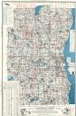
| Description: | This map shows 32 zoning districts, house numbering system, parks, cemeteries, and Milwaukee County institutional buildings. |
| Date: | 1963 |
|---|---|
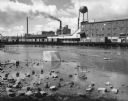
| Description: | A diagonal view down the canal of the Menasha Woodenware Company. Along the opposite side of the canal are boxcars on an elevated railroad track over the w... |

| Date: | 11 1965 |
|---|---|
| Description: | View looking down at a U.S. soldier, holding a rifle and carrying a radio unit on his back, sits on a large rock on a ridge overlooking a river. |

| Date: | 1969 |
|---|---|
| Description: | This map shows ghost towns, Indian reservations, lakes, railroads, and rivers. Ghost towns are numbered and listed in a corresponding index. |

| Date: | 01 1969 |
|---|---|
| Description: | A map of Oneida county, which includes a small drawing of a hodag. |

| Date: | 03 28 1964 |
|---|---|
| Description: | The University of Wisconsin crew is rowing down the Yahara River on a practice run, the four oarsmen stirring the water as they go. |
| Date: | 1960 |
|---|---|
| Description: | This map shows lakes arranged by county, depth maps of selected larger lakes, and enlargements of Mississippi River areas. The map also includes locations ... |

| Date: | 1965 |
|---|---|
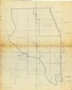
| Description: | This map shows landownership, acreages, and roads. The city of De Pere, the town of Hobart, and the Fox River are labeled. Inset maps showing Smits Subdivi... |

| Date: | 03 1965 |
|---|---|
| Description: | Keith Brigham is shown checking the U.S. Geological Survey stream gauging station located at the Yahara river locks on Lake Waubesa near McFarland. |

| Date: | 1962 |
|---|---|
| Description: | This map shows roads, golf courses, ski areas, boat landings, camp sites, waysides, parks, beaches, scenic views, virgin timber tracts, airports, boys and ... |

| Date: | 1960 |
|---|---|
| Description: | This map is a facsimile of a 1829 map and shows private land claims, landowners within military reserve boundaries, sawmill, Fort Howard, public barns, bri... |

| Date: | 1961 |
|---|---|
| Description: | This street map includes an ancillary map of Dane County highways and a business directory. Lake Mendota, Lake Monona, Monona Bay, Yahara River, and Lake W... |

| Date: | 1966 |
|---|---|
| Description: | This map shows city, suburban, parochial and other types schools, with an explanation of symbols in the right margin. The original caption for the map read... |
| Date: | 1967 |
|---|---|
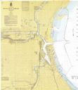
| Description: | This map shows the harbor, streets, and some buildings. Also includes the Menomonee River, the Kinnickinnic River, the Municipal mooring Basin, and Lake Mi... |

| Date: | 1969 |
|---|---|
| Description: | This map shows businesses, resorts, roads, public boat landings, schools, cemeteries, and location of fish and game. An inset map reads: Continuation along... |

| Date: | 08 1960 |
|---|---|
| Description: | This map shows a detailed account of southwestern Wisconsin. Individual settlers, the type of trees that grow in given areas, the quality of the soil (labe... |
If you didn't find the material you searched for, our Library Reference Staff can help.
Call our reference desk at 608-264-6535 or email us at: