 Filter: Categories of Wisconsin Historical Images
Filter: Subject of Rivers
Filter: Year of 1900-1999
Filter: Year of 1960-1969
Filter: Categories of Wisconsin Historical Images
Filter: Subject of Rivers
Filter: Year of 1900-1999
Filter: Year of 1960-1969

| Date: | 1960 |
|---|---|
| Description: | This map shows uplands and swamps owned by the Goodman Lumber Division, water, and roads. The lower right corner includes a location map. The upper left co... |

| Date: | 1960 |
|---|---|
| Description: | This pictorial map shows recreation activities, rivers, lakes, and the history of the area. The map covers Langlade County and parts of adjacent counties. ... |
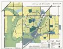
| Date: | 1962 |
|---|---|
| Description: | This map shows zoning, community facilities, roads, rivers and thoroughfares. The lower right corner includes a key titled "General Plan". |

| Date: | 1960 |
|---|---|
| Description: | This map shows improved town roads, federal highways, county highways, public boat access, public hunting areas, railroads, and lakes in the area around th... |

| Date: | 1960 |
|---|---|
| Description: | This map shows U.S. highways, state highways, county highways, town roads, county parks, county highway buildings, waysides, rivers, lakes, airports, a civ... |
| Date: | 1965 |
|---|---|
| Description: | This map covers the vicinity of Arbor Vitae, Woodruff, and Minocqua: east to Mishonagon Creek, west to Gilmore Lake, north to Lower Gresham Lake, and south... |

| Date: | 10 1969 |
|---|---|
| Description: | A street map of Janesville showing the block numbers on each street. Other landmarks are labeled such as chain stores, parks, schools, manufacturing compa... |

| Date: | 1965 |
|---|---|
| Description: | This series of 17 maps show boundaries and changes in city limits from 1846 to 1965. The base of all of the maps are the same, Milwaukee and suburbs. All m... |

| Date: | 1966 |
|---|---|
| Description: | This map shows trails, roads, creeks, alleged location of George Gardner's trading post, Boulder and Mud Lakes, and a portion of the Wolf River. The map al... |

| Date: | 1967 |
|---|---|
| Description: | Aerial view of the State University adjacent to the Chippewa River. Caption reads: "State University - Eau Claire, Eau Claire, Wis." |

| Date: | 1960 |
|---|---|
| Description: | This colored road map shows roads in Wisconsin as well as portions of nearby states. Information on the quality and type of any road shown can be found in ... |
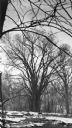
| Date: | 1968 |
|---|---|
| Description: | A towering specimen of Ulmus americana standing along the river in the Menomonee River Parkway. There are large blocks of ice on the shore. This tre... |

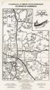
| Date: | 1962 |
|---|---|
| Description: | This tourist-oriented road map shows federal highways, state highways, county roads, and county lines in the "Blue Diamond Resort Area," a scenic space enc... |

| Date: | 1963 |
|---|---|
| Description: | This colored road map shows automobile roads in Wisconsin as well as portions of nearby states. The map is organized such that a single map of Wisconsin is... |
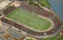
| Date: | 1965 |
|---|---|
| Description: | Overhead view of the football stadium before it was renamed Lambeau. The stadium is full of spectators and a game is in progress. |

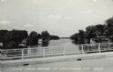
| Date: | 1968 |
|---|---|
| Description: | Color postcard view of the river flowing through Hattie Sherwood Park. |
| Date: | 1961 |
|---|---|
| Description: | View of the Rock River from a bridge at Hustisford. The river is lined with boathouses. Caption reads: "Scene from Bridge at Hustisford, Wis." |

| Date: | 1967 |
|---|---|
| Description: | A horse-drawn carriage carrying visitors is coming through a covered bridge at Stonefield Village. |
If you didn't find the material you searched for, our Library Reference Staff can help.
Call our reference desk at 608-264-6535 or email us at:

